Victoria_Park_Re port Final.pdf - City of Charlottetown
Victoria_Park_Re port Final.pdf - City of Charlottetown
Victoria_Park_Re port Final.pdf - City of Charlottetown

Create successful ePaper yourself
Turn your PDF publications into a flip-book with our unique Google optimized e-Paper software.
VICTORIA PARK COMPREHENSIVE MASTER PLAN<br />
<strong>Final</strong> <strong>Re</strong><strong>port</strong> • June 2013<br />
In 1873, approximately 40 acres <strong>of</strong> the Government Farm property was given to the<br />
city to be used exclusively as a public park. Extensive landscaping was done, bath<br />
houses were constructed and 600 loads <strong>of</strong> mud and debris were removed from Dead<br />
Man’s Pond. The 1873 plan <strong>of</strong> the <strong>City</strong> <strong>Park</strong> and Government Farm show this new<br />
public space. Two ponds are located within the new park, as is the battery. Within the<br />
Government Farm, the house, outbuildings and landscaping are depicted. This map also<br />
depicts the meridian stones erected in 1820.<br />
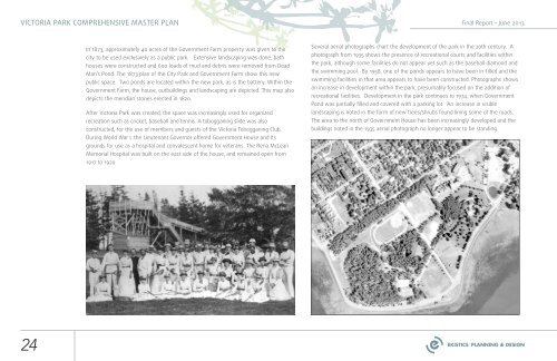
After <strong>Victoria</strong> <strong>Park</strong> was created, the space was increasingly used for organized<br />
recreation such as cricket, baseball and tennis. A tobogganing slide was also<br />
constructed, for the use <strong>of</strong> members and guests <strong>of</strong> the <strong>Victoria</strong> Tobogganing Club.<br />
During World War I, the Lieutenant Governor <strong>of</strong>fered Government House and its<br />
grounds for use as a hospital and convalescent home for veterans. The <strong>Re</strong>na McLean<br />
Memorial Hospital was built on the east side <strong>of</strong> the house, and remained open from<br />
1917 to 1920.<br />
Several aerial photographs chart the development <strong>of</strong> the park in the 20th century. A<br />
photograph from 1935 shows the presence <strong>of</strong> recreational courts and facilities within<br />
the park, although some facilities do not appear yet such as the baseball diamond and<br />
the swimming pool. By 1958, one <strong>of</strong> the ponds appears to have been in-filled and the<br />
swimming facilities in that area appears to have been constructed. Photographs shows<br />
an increase in development within the park, presumably focused on the addition <strong>of</strong><br />
recreational facilities. Development in the park continues to 1974, when Government<br />
Pond was partially filled and covered with a parking lot. An increase in visible<br />
landscaping is noted in the form <strong>of</strong> new trees/shrubs found lining some <strong>of</strong> the roads.<br />
The area to the north <strong>of</strong> Government House has been increasingly developed and the<br />
buildings noted in the 1935 aerial photograph no longer appear to be standing.<br />
24