Victoria_Park_Re port Final.pdf - City of Charlottetown
Victoria_Park_Re port Final.pdf - City of Charlottetown
Victoria_Park_Re port Final.pdf - City of Charlottetown

You also want an ePaper? Increase the reach of your titles
YUMPU automatically turns print PDFs into web optimized ePapers that Google loves.
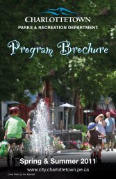
VICTORIA PARK COMPREHENSIVE MASTER PLAN<br />
<strong>Final</strong> <strong>Re</strong><strong>port</strong> • June 2013<br />
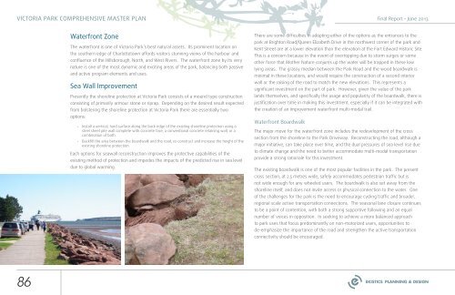
Waterfront Zone<br />
The waterfront is one <strong>of</strong> <strong>Victoria</strong> <strong>Park</strong>’s best natural assets. Its prominent location on<br />
the southern edge <strong>of</strong> <strong>Charlottetown</strong> affords visitors stunning views <strong>of</strong> the harbour and<br />
confluence <strong>of</strong> the Hillsborough, North, and West Rivers. The waterfront zone by its very<br />
nature is one <strong>of</strong> the most dynamic and exciting areas <strong>of</strong> the park, balancing both passive<br />
and active program elements and uses.<br />
Sea Wall Improvement<br />
Presently the shoreline protection at <strong>Victoria</strong> <strong>Park</strong> consists <strong>of</strong> a mound type construction<br />
consisting <strong>of</strong> primarily armour stone or riprap. Depending on the desired result expected<br />
from bolstering the shoreline protection at <strong>Victoria</strong> <strong>Park</strong> there are essentially two<br />
options:<br />
• Install a vertical, hard surface along the back edge <strong>of</strong> the existing shoreline protection using a<br />
steel sheet pile wall complete with concrete face, a conventional concrete retaining wall, or a<br />
combination <strong>of</strong> both.<br />
• Backfill the area between the boardwalk and the road, re-construct and increase the height <strong>of</strong> the<br />
existing shoreline protection.<br />
Each options for seawall reconstruction improves the protective capabilities <strong>of</strong> the<br />
existing method <strong>of</strong> protection and impedes the impacts <strong>of</strong> the predicted rise in sea level<br />
due to global warming.<br />
There are some difficulties in adopting either <strong>of</strong> the options as the entrances to the<br />
park at Brighton Road/Queen Elizabeth Drive in the northwest corner <strong>of</strong> the park and<br />
Kent Street are at a lower elevation than the elevation at the Fort Edward Historic Site.<br />
This is a concern because in the event <strong>of</strong> overtopping due to storm surges or some<br />
other force that Mother Nature conjures up the water will be trapped in these low<br />
lying areas. The grassy median between the <strong>Park</strong> Road and the wood boardwalk is<br />
minimal in these locations, and would require the construction <strong>of</strong> a second interior<br />
wall or the raising <strong>of</strong> the road to match the new elevations. This represents a<br />
significant investment on the part <strong>of</strong> park. However, given the value <strong>of</strong> the park<br />
lands themselves, and specifically the usage and popularity <strong>of</strong> the boardwalk, there is<br />
justification over time in making this investment, especially if it can be integrated with<br />
the creation <strong>of</strong> an improvement waterfront multi-modal trail.<br />
Waterfront Boardwalk<br />
The major move for the waterfront zone includes the redevelopment <strong>of</strong> the cross<br />
section from the shoreline to the <strong>Park</strong> Driveway. <strong>Re</strong>constructing the road, although a<br />
major initiative, can take place over time, and the dual pressures <strong>of</strong> sea level rise due<br />
to climate change and the need to better accommodate multi-modal trans<strong>port</strong>ation<br />
provide a strong rationale for this investment.<br />
The existing boardwalk is one <strong>of</strong> the most popular facilities in the park. The present<br />
cross section, at 2.5 metres wide, safely accommodates pedestrian traffic but is<br />
not wide enough for any wheeled users. The boardwalk is also set away from the<br />
shoreline itself, and does not invite access or physical connection to the water. One<br />
<strong>of</strong> the challenges for the park is the need to encourage cycling traffic and broader,<br />
regional scale active trans<strong>port</strong>ation connections. The seasonal lane closure continues<br />
to be a point <strong>of</strong> contention, with both a strong sup<strong>port</strong>ive following and an equal<br />
number <strong>of</strong> voices in opposition. In seeking to achieve a more balanced approach<br />
to park uses that focus predominantly on non-motorized users, op<strong>port</strong>unities to<br />
de-emphasize the im<strong>port</strong>ance <strong>of</strong> the road and strengthen the active trans<strong>port</strong>ation<br />
connectivity should be encouraged.<br />
86