Victoria_Park_Re port Final.pdf - City of Charlottetown
Victoria_Park_Re port Final.pdf - City of Charlottetown
Victoria_Park_Re port Final.pdf - City of Charlottetown

You also want an ePaper? Increase the reach of your titles
YUMPU automatically turns print PDFs into web optimized ePapers that Google loves.
<strong>Final</strong> <strong>Re</strong><strong>port</strong> • June 2013<br />
VICTORIA PARK COMPREHENSIVE MASTER PLAN<br />
In 1745, the British raided Louisbourg, resulting in the British seizure <strong>of</strong> the fort and their<br />
attack on Ile-Saint-Jean. Many settlers relocated to Quebec due to rumors <strong>of</strong> expulsion,<br />
but in 1748, the Island was once again under French control through the Treaty <strong>of</strong> Aixla-Chappelle.<br />
In 1751, Colonel Franquet, Officer <strong>of</strong> Engineers, visited Ile-Saint-Jean and<br />
left a description <strong>of</strong> principle settlements. He describes Port la Joye as surrounded<br />
by forest, with houses located along the sides <strong>of</strong> the valley. In 1755, the fall <strong>of</strong> Fort<br />
Beausejour and the Acadian de<strong>port</strong>ation prompted the arrival <strong>of</strong> approximately 2,000<br />
Acadians to the Island. In July 1758, Louisbourg capitulated and the French and Acadians<br />
living on Ile-Saint-Jean were also de<strong>port</strong>ed. A map dated to 1760 depicts Port-la-Joye,<br />
identifying the location <strong>of</strong> the fort with settled land along the shores <strong>of</strong> the harbour and<br />
rivers. However this postdates the de<strong>port</strong>ation in 1758. It is unclear whether the map<br />
was begun prior to the de<strong>port</strong>ation or is a depiction <strong>of</strong> what Port-la-Joye would have<br />
looked like before 1758. The map does not depict any settlement in the specific area <strong>of</strong><br />
<strong>Charlottetown</strong> and <strong>Victoria</strong> <strong>Park</strong>, although settlement is depicted all around the area.<br />
<strong>Charlottetown</strong> was <strong>of</strong>ficially designated the Island’s capital in 1768, at which point, the<br />
garrison was moved from Fort Amherst to Fort Edward which at this time was located<br />
on Great George Street. In 1769, the Island was separated from Nova Scotia and given<br />
its own government, including a Governor. The first Governor, Walter Patterson was<br />
appointed in 1769. A map tentatively dated to 1771 shows the layout <strong>of</strong> the city as<br />
designed by surveyor Thomas Wright for Governor Patterson, with a standard grid <strong>of</strong><br />
town plots surrounded by common lands. The study area is clearly included in the land<br />
set aside for common land and the watercourse described by Captain Holland in 1764<br />
can also been seen. Governor Patterson’s tenure on the Island was short-lived, due<br />
to scandal over the seizure and sale <strong>of</strong> lands, which lead to his eventual removal from<br />
<strong>of</strong>fice. His successor, Colonel Edmond Fanning was installed as the new Governor in<br />
1786. Colonel Fanning was responsible for the appropriation <strong>of</strong> approximately 100 acres<br />
<strong>of</strong> the commons for use as an estate and residence for the Lt. Governor. He also allowed<br />
the rest <strong>of</strong> the commons to be divided into private plots.<br />
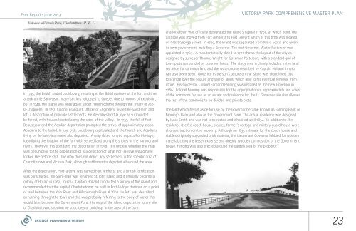
The land which he set aside for use by the Governor became known as Fanning Bank or<br />
Fanning’s Bank and also as the Government Farm. The actual residence was designed<br />
by Isaac Smith and was not constructed and inhabited until 1834. In addition to the<br />
residence itself, a coach house, stables, farmer’s cottage and military guard house were<br />
also construction on the property. Although an 1835 estimate for the coach house and<br />
stables originally suggested brick material, the Lieutenant Governor lobbied for wooden<br />
material, citing the lesser expense and already wooden composition <strong>of</strong> the Government<br />
House. Fencing was also erected around the garden area <strong>of</strong> the property.<br />
After the de<strong>port</strong>ation, Port-la-Joye was named Fort Amherst and a British fortification<br />
was constructed. Ile-Saint-Jean was renamed St. John Island and it <strong>of</strong>ficially became a<br />
colony <strong>of</strong> Britain in 1763. In 1764, Captain Holland conducted a survey <strong>of</strong> the island and<br />
recommended that the capital, <strong>Charlottetown</strong>, be built in Port-la-Joye Harbour, on a point<br />
<strong>of</strong> land between the York River and Hillsborough River. A “fine rivulet” was described<br />
as running through the town and this was probably referring to the body <strong>of</strong> water that<br />
would later become the Government Pond. His map <strong>of</strong> the island depicts the future site<br />
<strong>of</strong> <strong>Charlottetown</strong>, showing no structures or buildings in the area <strong>of</strong> the park.<br />
23