Rural Strategy - Surf Coast Shire
Rural Strategy - Surf Coast Shire
Rural Strategy - Surf Coast Shire

Create successful ePaper yourself
Turn your PDF publications into a flip-book with our unique Google optimized e-Paper software.
<strong>Surf</strong> <strong>Coast</strong> <strong>Shire</strong> <strong>Rural</strong> <strong>Strategy</strong> Review<br />
Final Report<br />
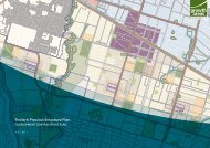
The landscape objectives noted in the Landscape Assessment include:<br />
To increase the indigenous vegetation in the precinct, particularly along creek and river<br />
valleys;<br />
To ensure shelter belt planting remains a feature of the area;<br />
To minimise the visual impact of development on the landscape;<br />
To retain the sense of openness and long distance views in the precinct; and<br />
To maintain the dominance of the open, rural landscape from main road corridors outside<br />
townships.<br />
Environmental Values<br />
The precinct is within the Victorian Volcanic Plains bioregion and prior to European<br />
settlement in 1750 featured extensive native grasslands with small patches of open<br />
woodlands and riparian vegetation along the rivers and shallow lakes. Over 95% of the<br />
native vegetation in the bioregion has been cleared primarily for agriculture, making what<br />
remains highly significant. The precinct includes a series of lakes, rivers, creeks wetlands<br />
and swamps. Lake Murdeduke is an extremely important site for waterbirds and large<br />
populations of international migratory species occur here. The lake is listed under the Ramsar<br />
Convention and Directory of Important Wetlands. The lake and surrounds has diverse<br />
aquatic habitats which contributes to the diversity of waterbirds, and is a breeding site for<br />
threatened water birds including the Freckled Duck (Stictonetta naevosa).<br />
The wetlands east of Lake Murdeduke provide critical Brolga (Grus rubicunda) habitat in<br />
Victoria for one of two core populations. The sites consist of several brackish and<br />
freshwater wetlands with extensive shallow water zones providing a diverse range of<br />
habitats. Kelly’s Swamp is a semi-saline wetland providing habitat for the Great Egret<br />
(Ardea alba) and other threatened water birds.<br />
The Barwon River supports endangered riparian vegetation and provides instream habitat<br />
for aquatic fauna and includes a series of wetlands that are also significant in the Bioregion.<br />
The river and wetlands provide habitat for numerous threatened water birds including<br />
Australasian Shoveler (Anas rhynchotis), Lathams Snipe (Gallinago hardwickii) and Royal<br />
Spoonbill (Platalea regia).<br />
The precinct also includes scattered paddock trees providing breeding sites and habitat for<br />
threatened fauna, and patches of endangered grassland and shrubland with a diverse range<br />
of native grasses and herbs species that is potential habitat for the nationally vulnerable<br />
Stripped Legless Lizard (Delma impar).<br />
Key attributes: A network of significant wetlands supporting endangered flora and fauna.<br />
Hollow bearing trees and intact grasslands.<br />
Key threats: Pollution of waterways from land use. Grazing by stock and weed invasion.<br />
Fragmentation of vegetation with poor linkages.<br />
RMCG Consultants for Business, Communities & Environment Page 64