Rural Strategy - Surf Coast Shire
Rural Strategy - Surf Coast Shire
Rural Strategy - Surf Coast Shire

You also want an ePaper? Increase the reach of your titles
YUMPU automatically turns print PDFs into web optimized ePapers that Google loves.
<strong>Surf</strong> <strong>Coast</strong> <strong>Shire</strong> <strong>Rural</strong> <strong>Strategy</strong> Review<br />
Final Report<br />
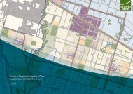
10.5 Precinct 3 Mixed Farming<br />
10.5.1 Description<br />
Precinct 3 extends east – west across the <strong>Shire</strong>, with the Princes Highway forming the<br />
northern boundary of the precinct, and the Cape Otway Road and Hendy Main Road<br />
generally defining the southern boundary.<br />
Current land use<br />
This precinct is predominantly used for beef and sheep grazing, though farms across the<br />
centre and eastern end of the precinct have a greater predominance of being managed for<br />
rural lifestyle and landscape purposes. A small, but economically significant, irrigated<br />
horticulture industry has developed based on the availability of recycled water from the Black<br />
Rock Sewerage Treatment Plant. Products include hydroponic tomatoes and turf and these<br />
businesses make a significant contribution to the <strong>Shire</strong>’s economy.<br />
Settlement patterns and urban development<br />
The settlement pattern is generally scattered farmhouses with a more dense settlement<br />
pattern in the east, including the Freshwater Creek area and two low density residential<br />
hamlets of Lower Duneed and Connewarre, and a more sparsely settled pattern in the west.<br />
The township of Moriac is centrally located in the precinct, with Winchelsea on the northernwestern<br />
boundary and Bellbrae, Torquay & Jan Juc on its eastern boundary. West of Moriac<br />
on the Cape Otway Road is an old, undeveloped township (Modewarre) which is not<br />
acknowledged as an urban settlement by way of its rural zoning.<br />
Allotment and tenements sizes<br />
There is a pattern of medium to smaller allotments and tenements, generally less than 60<br />
hectares, interspersed with larger holdings through the central and eastern end of the<br />
precinct, whereas in the west the predominant land holding is greater than 80 hectares. The<br />
Modewarre township comprises numerous small lots held in only a few ownerships.<br />
Agricultural quality<br />
The agricultural quality of the land across the precinct is predominantly Class 2-3 (high to<br />
moderate) with pockets of Class 1-2 (high) adjacent to the Barwon River in the west and<br />
Class 3 (moderate) and Class 4 (low) interspersed throughout. Agricultural quality is<br />
generally fairly consistent throughout the precinct.<br />
Future access to recycled water for irrigation could result in a reclassification (upgrading) of<br />
agricultural quality class for land in the south-eastern end of the precinct.<br />
Landscape characteristics and objective<br />
The landscape character type is predominantly that of the Western Plains (GORLASS,<br />
2003) comprising the sub-categories Winchelsea Western Plains in the west and Undulating<br />
Mixed Farming in the east. The landscape comprises flat to gently rolling topography<br />
occasionally divided by shelter belts, with some stands of remnant vegetation mainly<br />
RMCG Consultants for Business, Communities & Environment Page 71