Rural Strategy - Surf Coast Shire
Rural Strategy - Surf Coast Shire
Rural Strategy - Surf Coast Shire

You also want an ePaper? Increase the reach of your titles
YUMPU automatically turns print PDFs into web optimized ePapers that Google loves.
<strong>Surf</strong> <strong>Coast</strong> <strong>Shire</strong> <strong>Rural</strong> <strong>Strategy</strong> Review<br />
Final Report<br />
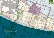
10.4 Precinct 2 – Barrabool<br />
10.4.1 Description<br />
Precinct 2 takes in the north-east corner of the <strong>Shire</strong>, north of the Princes Highway and east<br />
of the Barrabool and Pollocksford Roads.<br />
Current land use<br />
The land within the precinct is generally used for sheep and beef grazing with a small<br />
number of properties used for rural lifestyle purposes.<br />
Settlement patterns and urban development<br />
While the precinct is generally sparsely settled with farmhouses, there are stretches of<br />
smaller lot frontages that characterise some roads. There is no urban development in the<br />
precinct. The Ceres township is located further to the east within the City of Greater<br />
Geelong.<br />
Allotment and tenements sizes<br />
There is a varied pattern of settlement and lot sizes within the area. Large to moderate<br />
sized allotments and tenements of 40 to over 80 hectares predominates, intermixed with<br />
smaller lots and excisions.<br />
Agricultural quality<br />
The agricultural capability of the precinct is predominantly Class 2-3 (high to moderate) with<br />
a small area of moderate agricultural capability (Class 3) in the west.<br />
Landscape characteristics and objectives<br />
The Draft Landscape Assessment North of the Princes Highway (2007) identifies the<br />
character type of this precinct as Barrabool Hills and describes it as flat to gently rolling open<br />
topography, punctuated in some areas by volcanic outcrops and the volcanic cone of Mount<br />
Moriac. The landscape comprises mostly paddocks sporadically marked by shelterbelts with<br />
few stands of remnant vegetation. The Barwon River forms a relatively deeply dissected<br />
northern boundary to the precinct<br />
The key landscape characteristics include:<br />
Hilly topography of the Barrabool Hills and scenic Barwon River escarpment.<br />
Elevated long distance views across the <strong>Shire</strong> and beyond.<br />
Homesteads, sheds and associated gardens in distinct clusters (particularly historic<br />
buildings).<br />
The roads and sporadic shelterbelt plantings draped across the landscape emphasising<br />
the rolling topography.<br />
RMCG Consultants for Business, Communities & Environment Page 67