

findings by bioregion - Victorian Environmental Assessment Council
findings by bioregion - Victorian Environmental Assessment Council
findings by bioregion - Victorian Environmental Assessment Council

Create successful ePaper yourself
Turn your PDF publications into a flip-book with our unique Google optimized e-Paper software.
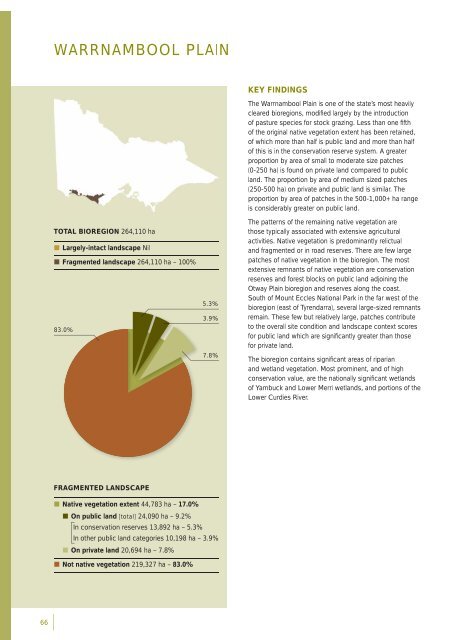
WARRNAMBOOL PLAINTOTAL BIOREGION 264,110 ha• Largely-intact landscape Nil• Fragmented landscape 264,110 ha – 100%83.0%5.3%3.9%7.8%KEY FINDINGSThe Warrnambool Plain is one of the state’s most heavilycleared <strong>bioregion</strong>s, modifi ed largely <strong>by</strong> the introductionof pasture species for stock grazing. Less than one fi fthof the original native vegetation extent has been retained,of which more than half is public land and more than halfof this is in the conservation reserve system. A greaterproportion <strong>by</strong> area of small to moderate size patches(0-250 ha) is found on private land compared to publicland. The proportion <strong>by</strong> area of medium sized patches(250-500 ha) on private and public land is similar. Theproportion <strong>by</strong> area of patches in the 500-1,000+ ha rangeis considerably greater on public land.The patterns of the remaining native vegetation arethose typically associated with extensive agriculturalactivities. Native vegetation is predominantly relictualand fragmented or in road reserves. There are few largepatches of native vegetation in the <strong>bioregion</strong>. The mostextensive remnants of native vegetation are conservationreserves and forest blocks on public land adjoining theOtway Plain <strong>bioregion</strong> and reserves along the coast.South of Mount Eccles National Park in the far west of the<strong>bioregion</strong> (east of Tyrendarra), several large-sized remnantsremain. These few but relatively large, patches contributeto the overall site condition and landscape context scoresfor public land which are signifi cantly greater than thosefor private land.The <strong>bioregion</strong> contains signifi cant areas of riparianand wetland vegetation. Most prominent, and of highconservation value, are the nationally signifi cant wetlandsof Yambuck and Lower Merri wetlands, and portions of theLower Curdies River.FRAGMENTED LANDSCAPE• Native vegetation extent 44,783 ha – 17.0%• On public land [total] 24,090 ha – 9.2%In conservation reserves 13,892 ha – 5.3%In other public land categories 10,198 ha – 3.9%• On private land 20,694 ha – 7.8%• Not native vegetation 219,327 ha – 83.0%66


