

findings by bioregion - Victorian Environmental Assessment Council
findings by bioregion - Victorian Environmental Assessment Council
findings by bioregion - Victorian Environmental Assessment Council

You also want an ePaper? Increase the reach of your titles
YUMPU automatically turns print PDFs into web optimized ePapers that Google loves.
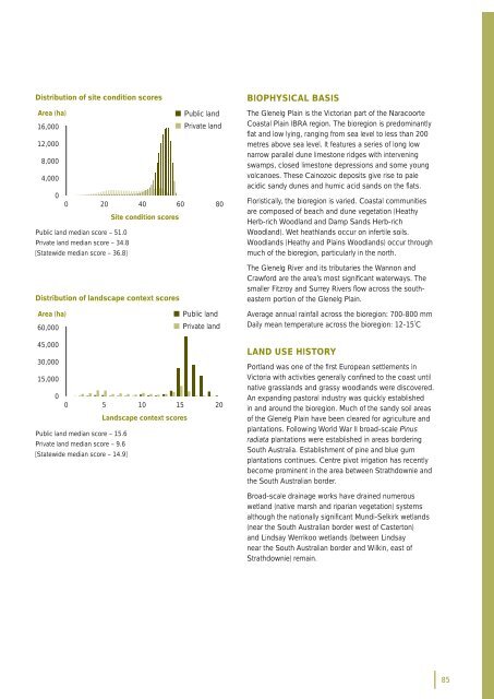
Distribution of site condition scoresArea (ha)• Public land16,000• Private land12,0008,0004,00000 20 40 60 80Site condition scoresPublic land median score – 51.0Private land median score – 34.8[Statewide median score – 36.8]Distribution of landscape context scoresBIOPHYSICAL BASISThe Glenelg Plain is the <strong>Victorian</strong> part of the NaracoorteCoastal Plain IBRA region. The <strong>bioregion</strong> is predominantlyfl at and low lying, ranging from sea level to less than 200metres above sea level. It features a series of long lownarrow parallel dune limestone ridges with interveningswamps, closed limestone depressions and some youngvolcanoes. These Cainozoic deposits give rise to paleacidic sandy dunes and humic acid sands on the fl ats.Floristically, the <strong>bioregion</strong> is varied. Coastal communitiesare composed of beach and dune vegetation (HeathyHerb-rich Woodland and Damp Sands Herb-richWoodland). Wet heathlands occur on infertile soils.Woodlands (Heathy and Plains Woodlands) occur throughmuch of the <strong>bioregion</strong>, particularly in the north.The Glenelg River and its tributaries the Wannon andCrawford are the area’s most signifi cant waterways. Thesmaller Fitzroy and Surrey Rivers fl ow across the southeasternportion of the Glenelg Plain.Area (ha)60,000• Public land• Private landAverage annual rainfall across the <strong>bioregion</strong>: 700-800 mmDaily mean temperature across the <strong>bioregion</strong>: 12-15˚C45,00030,00015,00000 5 10 15 20Landscape context scoresPublic land median score – 15.6Private land median score – 9.6[Statewide median score – 14.9]LAND USE HISTORYPortland was one of the fi rst European settlements inVictoria with activities generally confi ned to the coast untilnative grasslands and grassy woodlands were discovered.An expanding pastoral industry was quickly establishedin and around the <strong>bioregion</strong>. Much of the sandy soil areasof the Glenelg Plain have been cleared for agriculture andplantations. Following World War II broad-scale Pinusradiata plantations were established in areas borderingSouth Australia. Establishment of pine and blue gumplantations continues. Centre pivot irrigation has recentlybecome prominent in the area between Strathdownie andthe South Australian border.Broad-scale drainage works have drained numerouswetland (native marsh and riparian vegetation) systemsalthough the nationally signifi cant Mundi-Selkirk wetlands(near the South Australian border west of Casterton)and Lindsay Werrikoo wetlands (between Lindsaynear the South Australian border and Wilkin, east ofStrathdownie) remain.85


