

findings by bioregion - Victorian Environmental Assessment Council
findings by bioregion - Victorian Environmental Assessment Council
findings by bioregion - Victorian Environmental Assessment Council

You also want an ePaper? Increase the reach of your titles
YUMPU automatically turns print PDFs into web optimized ePapers that Google loves.
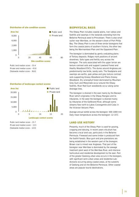
Distribution of site condition scoresArea (ha)• Public land8,000• Private land6,0002,0001,00000 20 40 60 80Site condition scoresPublic land median score – 53.4Private land median score – 43.8[Statewide median score – 36.8]Distribution of landscape context scoresArea (ha)• Public land20,000• Private land15,00010,0005,000BIOPHYSICAL BASISThe Otway Plain includes coastal plains, river valleys andfoothills and swamps in the lowlands extending from theBellarine Peninsula west to Princetown. There is also smalloutlier near Werribee, on the western shore of Port PhillipBay. The Otway Plain is one of three similar <strong>bioregion</strong>s thatform the coastal plains of southern Victoria, the other twobeing the Warrnambool Plain and the Gippsland Plain.The <strong>bioregion</strong> is dominated <strong>by</strong> gently undulating plainsof Tertiary deposits. Ridges mark positions of ancientshorelines. Soils types and fertility vary across the<strong>bioregion</strong>. The soils associated with the upper terrain aretexture contrast soils and support Lowland Forest andHeathy Woodland EVCs. The dunes around Anglesea arepredominantly low fertile, sandy soils. The fl oodplains andswamps are earths, pale yellow and grey texture contrastsoils supporting Grassy Woodland and Plains GrassyWoodland. Dry sclerophyll forest dominated <strong>by</strong> MountainGrey Gum and Messmate occur around the Otwayfoothills. River Red Gum woodlands occur along somedrainage lines.The <strong>bioregion</strong> is drained in the east mainly <strong>by</strong> the BarwonRiver (which originates in the Otway Ranges) and itstributaries. In the west the <strong>bioregion</strong> is drained mainly<strong>by</strong> tributaries of the Gellibrand River, although somestreams fl ow north to Lakes Corangamite and Colac inthe <strong>Victorian</strong> Volcanic Plain.00 5 10 15 20Landscape context scoresAverage annual rainfall across the <strong>bioregion</strong>: 500-1000 mmDaily mean temperature across the <strong>bioregion</strong>: 12-15˚CPublic land median score – 15.7Private land median score – 13.5[Statewide median score – 14.9]LAND USE HISTORYPresently, much of the Otway Plain is used for grazing,cropping and dairying. In recent years viticulture hasbecome a local land-use, particularly in the BellarinePeninsula. Firewood and some timber is produced fromthe foothill forests. Blue gum and pine plantations arebeing established in the western part of the <strong>bioregion</strong>.Brown coal is mined near Anglesea. That part of the<strong>bioregion</strong> near Werribee is dominated <strong>by</strong> the sewagetreatment plant west of the Werribee River, and intensivehorticulture and residential development to the east. Partof the greater Geelong urban area occurs in the <strong>bioregion</strong>,with signifi cant semi-urban areas and residential subdivisionsoccurring along coastal areas, at the outskirtsof Geelong and on the Bellarine Peninsula. Other coastalareas are popular tourist destinations.79


