

findings by bioregion - Victorian Environmental Assessment Council
findings by bioregion - Victorian Environmental Assessment Council
findings by bioregion - Victorian Environmental Assessment Council

Create successful ePaper yourself
Turn your PDF publications into a flip-book with our unique Google optimized e-Paper software.
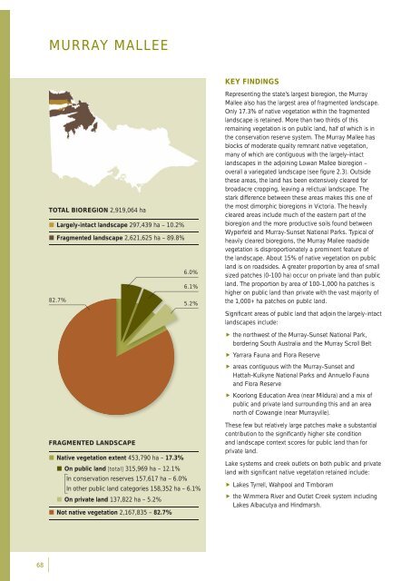
MURRAY MALLEEKEY FINDINGSTOTAL BIOREGION 2,919,064 ha• Largely-intact landscape 297,439 ha – 10.2%• Fragmented landscape 2,621,625 ha – 89.8%6.0%6.1%82.7%5.2%Representing the state’s largest <strong>bioregion</strong>, the MurrayMallee also has the largest area of fragmented landscape.Only 17.3% of native vegetation within the fragmentedlandscape is retained. More than two thirds of thisremaining vegetation is on public land, half of which is inthe conservation reserve system. The Murray Mallee hasblocks of moderate quality remnant native vegetation,many of which are contiguous with the largely-intactlandscapes in the adjoining Lowan Mallee <strong>bioregion</strong> –overall a variegated landscape (see fi gure 2.3). Outsidethese areas, the land has been extensively cleared forbroadacre cropping, leaving a relictual landscape. Thestark difference between these areas makes this one ofthe most dimorphic <strong>bioregion</strong>s in Victoria. The heavilycleared areas include much of the eastern part of the<strong>bioregion</strong> and the more productive soils found betweenWyperfeld and Murray-Sunset National Parks. Typical ofheavily cleared <strong>bioregion</strong>s, the Murray Mallee roadsidevegetation is disproportionately a prominent feature ofthe landscape. About 15% of native vegetation on publicland is on roadsides. A greater proportion <strong>by</strong> area of smallsized patches (0-100 ha) occur on private land than publicland. The proportion <strong>by</strong> area of 100-1,000 ha patches ishigher on public land than private with the vast majority ofthe 1,000+ ha patches on public land.Signifi cant areas of public land that adjoin the largely-intactlandscapes include: the northwest of the Murray-Sunset National Park,bordering South Australia and the Murray Scroll Belt Yarrara Fauna and Flora Reserve areas contiguous with the Murray-Sunset andHattah-Kulkyne National Parks and Annuello Faunaand Flora Reserve Koorlong Education Area (near Mildura) and a mix ofpublic and private land surrounding this and an areanorth of Cowangie (near Murrayville).FRAGMENTED LANDSCAPE• Native vegetation extent 453,790 ha – 17.3%• On public land [total] 315,969 ha – 12.1%In conservation reserves 157,617 ha – 6.0%In other public land categories 158,352 ha – 6.1%• On private land 137,822 ha – 5.2%• Not native vegetation 2,167,835 – 82.7%These few but relatively large patches make a substantialcontribution to the signifi cantly higher site conditionand landscape context scores for public land than forprivate land.Lake systems and creek outlets on both public and privateland with signifi cant native vegetation retained include: Lakes Tyrrell, Wahpool and Timboram the Wimmera River and Outlet Creek system includingLakes Albacutya and Hindmarsh.68


