

findings by bioregion - Victorian Environmental Assessment Council
findings by bioregion - Victorian Environmental Assessment Council
findings by bioregion - Victorian Environmental Assessment Council

Create successful ePaper yourself
Turn your PDF publications into a flip-book with our unique Google optimized e-Paper software.
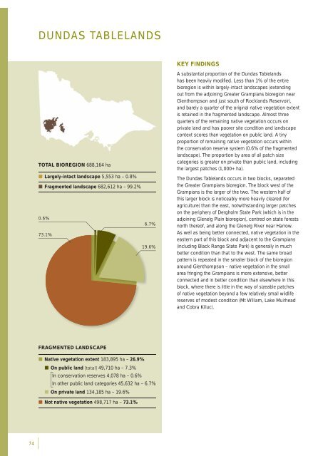
DUNDAS TABLELANDSKEY FINDINGSTOTAL BIOREGION 688,164 ha• Largely-intact landscape 5,553 ha – 0.8%• Fragmented landscape 682,612 ha – 99.2%0.6%6.7%73.1%19.6%A substantial proportion of the Dundas Tablelandshas been heavily modifi ed. Less than 1% of the entire<strong>bioregion</strong> is within largely-intact landscapes (extendingout from the adjoining Greater Grampians <strong>bioregion</strong> nearGlenthompson and just south of Rocklands Reservoir),and barely a quarter of the original native vegetation extentis retained in the fragmented landscape. Almost threequarters of the remaining native vegetation occurs onprivate land and has poorer site condition and landscapecontext scores than vegetation on public land. A tinyproportion of remaining native vegetation occurs withinthe conservation reserve system (0.6% of the fragmentedlandscape). The proportion <strong>by</strong> area of all patch sizecategories is greater on private than public land, includingthe largest patches (1,000+ ha).The Dundas Tablelands occurs in two blocks, separatedthe Greater Grampians <strong>bioregion</strong>. The block west of theGrampians is the larger of the two. The western half ofthis larger block is noticeably more heavily cleared (foragriculture) than the east, notwithstanding larger patcheson the periphery of Dergholm State Park (which is in theadjoining Glenelg Plain <strong>bioregion</strong>), centred on state forestsnorth thereof, and along the Glenelg River near Harrow.As well as being better connected, native vegetation in theeastern part of this block and adjacent to the Grampians(including Black Range State Park) is generally in muchbetter condition than that to the west. The same broadpattern is repeated in the smaller block of the <strong>bioregion</strong>around Glenthompson – native vegetation in the smallarea fringing the Grampians is more extensive, betterconnected and in better condition than elsewhere in thisblock, where there is little in the way of sizeable patchesof native vegetation beyond a few relatively small wildlifereserves of modest condition (Mt William, Lake Muirheadand Cobra Killuc).FRAGMENTED LANDSCAPE• Native vegetation extent 183,895 ha – 26.9%• On public land [total] 49,710 ha – 7.3%In conservation reserves 4,078 ha – 0.6%In other public land categories 45,632 ha – 6.7%• On private land 134,185 ha – 19.6%• Not native vegetation 498,717 ha – 73.1%74


