

findings by bioregion - Victorian Environmental Assessment Council
findings by bioregion - Victorian Environmental Assessment Council
findings by bioregion - Victorian Environmental Assessment Council

Create successful ePaper yourself
Turn your PDF publications into a flip-book with our unique Google optimized e-Paper software.
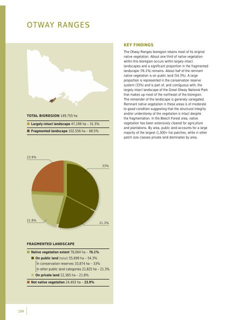
OTWAY RANGESKEY FINDINGSTOTAL BIOREGION 149,755 ha• Largely-intact landscape 47,199 ha – 31.5%• Fragmented landscape 102,556 ha – 68.5%The Otway Ranges <strong>bioregion</strong> retains most of its originalnative vegetation. About one third of native vegetationwithin this <strong>bioregion</strong> occurs within largely-intactlandscapes and a signifi cant proportion in the fragmentedlandscape (76.1%) remains. About half of the remnantnative vegetation is on public land (54.3%). A largeproportion is represented in the conservation reservesystem (33%) and is part of, and contiguous with, thelargely-intact landscape of the Great Otway National Parkthat makes up most of the northeast of the <strong>bioregion</strong>.The remainder of the landscape is generally variegated.Remnant native vegetation in these areas is of moderateto good condition suggesting that the structural integrityand/or understorey of the vegetation is intact despitethe fragmentation. In the Beech Forest area, nativevegetation has been extensively cleared for agricultureand plantations. By area, public land accounts for a largemajority of the largest (1,000+ ha) patches, while in otherpatch size classes private land dominates <strong>by</strong> area.23.9%33%21.8%21.3%FRAGMENTED LANDSCAPE• Native vegetation extent 78,064 ha – 76.1%• On public land [total] 55,699 ha – 54.3%In conservation reserves 33,874 ha – 33%In other public land categories 21,825 ha – 21.3%• On private land 22,365 ha – 21.8%• Not native vegetation 24,493 ha – 23.9%104


