

findings by bioregion - Victorian Environmental Assessment Council
findings by bioregion - Victorian Environmental Assessment Council
findings by bioregion - Victorian Environmental Assessment Council

You also want an ePaper? Increase the reach of your titles
YUMPU automatically turns print PDFs into web optimized ePapers that Google loves.
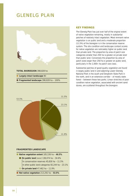
GLENELG PLAINKEY FINDINGSThe Glenelg Plain has just over half of the original extentof native vegetation remaining, mostly in substantialpatches of relatively intact vegetation. Most remnant nativevegetation is on public land and a moderate proportion(11.5%) of the <strong>bioregion</strong> is in the conservation reservesystem. The site condition and landscape context scoresfor native vegetation are noticeably higher on public landthan private land. The proportion <strong>by</strong> area of patch sizecategories smaller than 250 ha is greater on private landthan public land. Conversely the proportion <strong>by</strong> area ofpatch sizes larger than 250 ha is greater on public land,particularly in the 1,000+ ha patch size class.TOTAL BIOREGION 398,828 ha• Largely-intact landscape Nil• Fragmented landscape 398,828 ha – 100%Substantial patches of good quality vegetation are foundin largely public land in and adjoining Lower GlenelgNational Park in the south and Dergholm State Park inthe north, and in an extensive corridor – of mostly stateforest – between these two parks. Linear stretches of poorcondition native vegetation, associated with ancient sanddunes, are scattered throughout the <strong>bioregion</strong>.53.5%11.5%23.1%11.9%FRAGMENTED LANDSCAPE• Native vegetation extent 185,536 ha – 46.5%• On public land [total] 138,074 ha – 34.6%In conservation reserves 45,830 ha – 11.5%In other public land categories 92,244 ha – 23.1%• On private land 47,462 ha – 11.9%• Not native vegetation 213,292 ha – 53.5%84


