

findings by bioregion - Victorian Environmental Assessment Council
findings by bioregion - Victorian Environmental Assessment Council
findings by bioregion - Victorian Environmental Assessment Council

You also want an ePaper? Increase the reach of your titles
YUMPU automatically turns print PDFs into web optimized ePapers that Google loves.
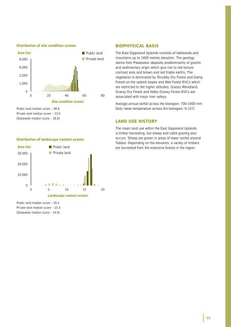
Distribution of site condition scoresArea (ha)• Public land8,000• Private land6,0002,0001,00000 20 40 60 80Site condition scoresPublic land median score – 48.8Private land median score – 33.9[Statewide median score – 36.8]Distribution of landscape context scoresArea (ha)• Public land30,000• Private landBIOPHYSICAL BASISThe East Gippsland Uplands consists of tablelands andmountains up to 1400 metres elevation. The geologystems from Palaeozoic deposits predominantly of graniticand sedimentary origin which give rise to red texturecontrast soils and brown and red friable earths. Thevegetation is dominated <strong>by</strong> Shrub<strong>by</strong> Dry Forest and DampForest on the upland slopes and Wet Forest EVCs whichare restricted to the higher altitudes; Grassy Woodland,Grassy Dry Forest and Valley Grassy Forest EVCs areassociated with major river valleys.Average annual rainfall across the <strong>bioregion</strong>: 700-1400 mmDaily mean temperature across the <strong>bioregion</strong>: 9-15˚CLAND USE HISTORYThe major land use within the East Gippsland Uplandsis timber harvesting, but sheep and cattle grazing alsooccurs. Sheep are grown in areas of lower rainfall aroundTubbut. Depending on the elevation, a variety of timbersare harvested from the extensive forests in the region.20,00010,00000 5 10 15 20Landscape context scoresPublic land median score – 16.2Private land median score – 15.4[Statewide median score – 14.9]99


