

findings by bioregion - Victorian Environmental Assessment Council
findings by bioregion - Victorian Environmental Assessment Council
findings by bioregion - Victorian Environmental Assessment Council

You also want an ePaper? Increase the reach of your titles
YUMPU automatically turns print PDFs into web optimized ePapers that Google loves.
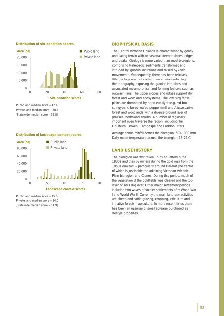
Distribution of site condition scoresArea (ha)• Public land20,000• Private land15,00010,0005,00000 20 40 60 80Site condition scoresPublic land median score – 47.1Private land median score – 30.4[Statewide median score – 36.8]Distribution of landscape context scoresArea (ha) • Public land80,000• Private land60,00040,00020,00000 5 10 15 20Landscape context scoresPublic land median score – 15.6Private land median score – 14.0[Statewide median score – 14.9]BIOPHYSICAL BASISThe Central <strong>Victorian</strong> Uplands is characterised <strong>by</strong> gentlyundulating terrain with occasional steeper slopes, ridgesand peaks. Geology is more varied than most <strong>bioregion</strong>s,comprising Palaeozoic sediments transformed andintruded <strong>by</strong> igneous incursions and raised <strong>by</strong> earthmovements. Subsequently, there has been relativelylittle geological activity other than erosion subduingthe topography, exposing the granitic intrusions andassociated metamorphics, and forming features such asoutwash fans. The upper slopes and ridges support dryforest and woodland ecosystems. The low lying fertileplains are dominated <strong>by</strong> open eucalypt (e.g. red box,stringybark, broad-leafed peppermint) and Allocasuarinaforest and woodlands with a diverse ground layer ofgrasses, herbs and shrubs. A number of regionallyimportant rivers traverse the region, including theGoulburn, Broken, Campaspe and Loddon Rivers.Average annual rainfall across the <strong>bioregion</strong>: 600-1000 mmDaily mean temperature across the <strong>bioregion</strong>: 15-21˚CLAND USE HISTORYThe <strong>bioregion</strong> was fi rst taken up <strong>by</strong> squatters in the1830s and then <strong>by</strong> miners during the gold rush from the1850s onwards – particularly around Ballarat (the centreof which is just inside the adjoining <strong>Victorian</strong> VolcanicPlain <strong>bioregion</strong>) and Clunes. During this period, much ofthe vegetation of the goldfi elds was cleared and the toplayer of soils dug over. Other major settlement periodsincluded two waves of soldier settlements after World WarI and World War II. Currently the main land-use activitiesare sheep and cattle grazing, cropping, viticulture and –in native forests – apiculture. In more recent times therehas been an upsurge of small acreage purchased aslifestyle properties.83


