

findings by bioregion - Victorian Environmental Assessment Council
findings by bioregion - Victorian Environmental Assessment Council
findings by bioregion - Victorian Environmental Assessment Council

Create successful ePaper yourself
Turn your PDF publications into a flip-book with our unique Google optimized e-Paper software.
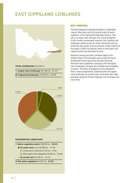
EAST GIPPSLAND LOWLANDSKEY FINDINGSThe East Gippsland Lowlands <strong>bioregion</strong> is moderatelycleared. More than half of the original extent of nativevegetation in the fragmented landscape remains. Overhalf is on public land, although only a small proportion(3.9%) is within conservation reserves. Site condition andlandscape context scores for public and private land aresimilar. By area, public land accounts for a large majority ofthe largest (1,000+ ha) patches, while in other patch sizeclasses private land dominates <strong>by</strong> area.TOTAL BIOREGION 531,830 ha• Largely-intact landscape 357,394 ha – 67.2%• Fragmented landscape 174,436 ha – 32.8%Extensive clearing has been confi ned largely to thewestern fi nger of the <strong>bioregion</strong> east to Lakes Entranceand Bruthen where agricultural activities dominate.Remnant native vegetation contiguous with the largelyintactlandscape is of good site condition and variegatedin pattern. The fl atter land adjacent to the GippslandPlain is heavily fragmented. Scattered within the largelyintactlandscape are cleared areas associated with majortownships along the Princes Highway such as Orbost andCann River.3.9%37.6%33.4%25.1%FRAGMENTED LANDSCAPE• Native vegetation extent 108,839 ha – 62.4%• On public land [total] 65,080 ha – 37.3%In conservation reserves 6,724 ha – 3.9%In other public land categories 58,356 ha – 33.4%• On private land 43,760 ha – 25.1%• Not native vegetation 65,597 ha – 37.6%94


