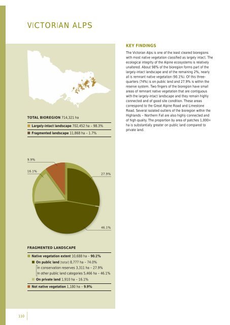
VICTORIAN ALPSKEY FINDINGSTOTAL BIOREGION 714,321 ha• Largely-intact landscape 702,452 ha – 98.3%• Fragmented landscape 11,868 ha – 1.7%The <strong>Victorian</strong> Alps is one of the least cleared <strong>bioregion</strong>swith most native vegetation classifi ed as largely intact. Theecological integrity of the Alpine ecosystems is relativelyunaltered. About 98% of the <strong>bioregion</strong> forms part of thelargely-intact landscape and of the remaining 2%, nearlyall is remnant native vegetation (90.1%). Of this threequarters(74%) is on public land and 27.9% is within thereserve system. Two fi ngers of the <strong>bioregion</strong> have smallareas of remnant native vegetation that are contiguouswith the largely-intact landscape and they remain highlyconnected and of good site condition. These areascorrespond to the Great Alpine Road and LimestoneRoad. Several isolated outliers of the <strong>bioregion</strong> within theHighlands – Northern Fall are also highly connected andof high quality. The proportion <strong>by</strong> area of patches 1,000+ha is substantially greater on public land compared toprivate land.9.9%16.1%27.9%46.1%FRAGMENTED LANDSCAPE• Native vegetation extent 10,688 ha – 90.1%• On public land [total] 8,777 ha – 74.0%In conservation reserves 3,311 ha – 27.9%In other public land categories 5,466 ha – 46.1%• On private land 1,910 ha – 16.1%• Not native vegetation 1,180 ha – 9.9%110
Distribution of site condition scoresArea (ha)• Public land1,000• Private land7,5005,0002,50000 20 40 60 80Site condition scoresPublic land median score – 50.7Private land median score – 42.0[Statewide median score – 36.8]Distribution of landscape context scoresArea (ha)• Public land5,000• Private land4,0003,0002,0001,00000 5 10 15 20Landscape context scoresPublic land median score – 16.8Private land median score – 15.9[Statewide median score – 14.9]BIOPHYSICAL BASISThe <strong>Victorian</strong> Alps is part of a series of high plateauxand peaks along the Great Dividing Range. The geologyconsists of Palaeozoic deposits predominantly of graniticand basaltic origin that give rise to friable leached earths,loams and peaty soils.The <strong>bioregion</strong> consists of a complex mosaic of ecologicalcommunities determined <strong>by</strong> soils, climate and topography.The vegetation associated with the plateaux are SubalpineWoodland, Treeless Sub-alpine Mosaic and SubalpineGrassland EVCs. The upper slopes and generallysurrounding sub-alpine areas are dominated <strong>by</strong> MontaneDry Woodland, Montane Damp Forest, Montane WetForest and Montane Grassy Woodland. Many of thesevegetation types are extremely limited in extent, and oftenthe characteristic species of alpine biota are themselvesrestricted to only one or two of these EVCs.Many of Victoria’s major river systems, including theMurray, Goulburn, Ovens, King, Kiewa and Mitchell, havetheir sources in the alpine areas.Average annual rainfall across the <strong>bioregion</strong>: 800-1600 mmSnowfalls occur during winter.Daily mean temperature across the <strong>bioregion</strong>: 6-9˚CLAND USE HISTORYThe major European land-use activities are conservation,recreation (including commercial tourism), forestry,hydro electricity generation and water production andcatchment protection. The alpine areas have no largepermanent settlements except for the fi ve Alpine ResortAreas. Inaccessibility, rugged topography and the hostileclimate of the alpine area inhibited large-scale permanentsettlement, but the high plateaus have been used assummer pasture for cattle and sheep from the 1850s.Early settlements developed in the valleys during the goldrushes of the last century were abandoned. The expansionof forestry operations in the <strong>Victorian</strong> Alps from the 1940sled to the development of an extensive road systemthrough the area, which had enabled access for otherusers, particularly recreational users.111