

findings by bioregion - Victorian Environmental Assessment Council
findings by bioregion - Victorian Environmental Assessment Council
findings by bioregion - Victorian Environmental Assessment Council

Create successful ePaper yourself
Turn your PDF publications into a flip-book with our unique Google optimized e-Paper software.
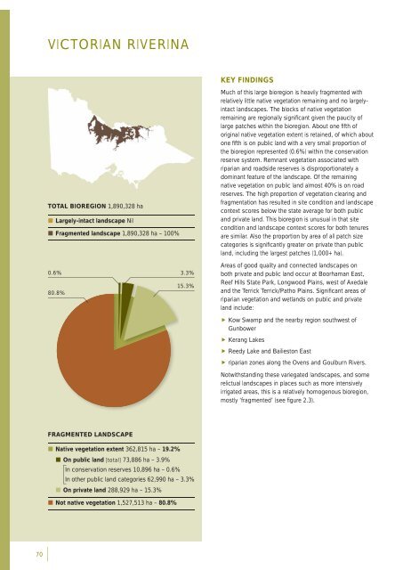
VICTORIAN RIVERINAKEY FINDINGSTOTAL BIOREGION 1,890,328 ha• Largely-intact landscape Nil• Fragmented landscape 1,890,328 ha – 100%0.6% 3.3%15.3%80.8%Much of this large <strong>bioregion</strong> is heavily fragmented withrelatively little native vegetation remaining and no largelyintactlandscapes. The blocks of native vegetationremaining are regionally signifi cant given the paucity oflarge patches within the <strong>bioregion</strong>. About one fi fth oforiginal native vegetation extent is retained, of which aboutone fi fth is on public land with a very small proportion ofthe <strong>bioregion</strong> represented (0.6%) within the conservationreserve system. Remnant vegetation associated withriparian and roadside reserves is disproportionately adominant feature of the landscape. Of the remainingnative vegetation on public land almost 40% is on roadreserves. The high proportion of vegetation clearing andfragmentation has resulted in site condition and landscapecontext scores below the state average for both publicand private land. This <strong>bioregion</strong> is unusual in that sitecondition and landscape context scores for both tenuresare similar. Also the proportion <strong>by</strong> area of all patch sizecategories is signifi cantly greater on private than publicland, including the largest patches (1,000+ ha).Areas of good quality and connected landscapes onboth private and public land occur at Boorhaman East,Reef Hills State Park, Longwood Plains, west of Axedaleand the Terrick Terrick/Patho Plains. Signifi cant areas ofriparian vegetation and wetlands on public and privateland include: Kow Swamp and the near<strong>by</strong> region southwest ofGunbower Kerang Lakes Reedy Lake and Bailieston East riparian zones along the Ovens and Goulburn Rivers.Notwithstanding these variegated landscapes, and somerelictual landscapes in places such as more intensivelyirrigated areas, this is a relatively homogenous <strong>bioregion</strong>,mostly ‘fragmented’ (see fi gure 2.3).FRAGMENTED LANDSCAPE• Native vegetation extent 362,815 ha – 19.2%• On public land [total] 73,886 ha – 3.9%In conservation reserves 10,896 ha – 0.6%In other public land categories 62,990 ha – 3.3%• On private land 288,929 ha – 15.3%• Not native vegetation 1,527,513 ha – 80.8%70


