

findings by bioregion - Victorian Environmental Assessment Council
findings by bioregion - Victorian Environmental Assessment Council
findings by bioregion - Victorian Environmental Assessment Council

You also want an ePaper? Increase the reach of your titles
YUMPU automatically turns print PDFs into web optimized ePapers that Google loves.
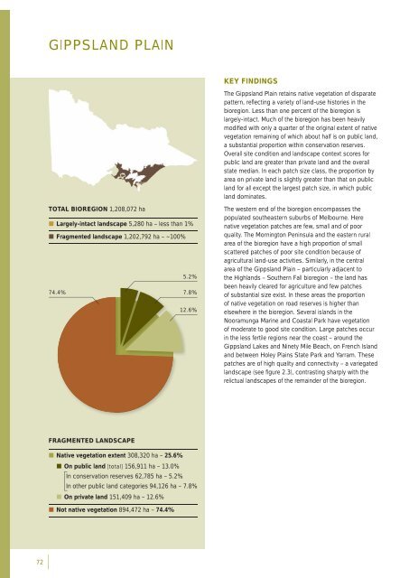
GIPPSLAND PLAINKEY FINDINGSThe Gippsland Plain retains native vegetation of disparatepattern, refl ecting a variety of land-use histories in the<strong>bioregion</strong>. Less than one percent of the <strong>bioregion</strong> islargely-intact. Much of the <strong>bioregion</strong> has been heavilymodifi ed with only a quarter of the original extent of nativevegetation remaining of which about half is on public land,a substantial proportion within conservation reserves.Overall site condition and landscape context scores forpublic land are greater than private land and the overallstate median. In each patch size class, the proportion <strong>by</strong>area on private land is slightly greater than that on publicland for all except the largest patch size, in which publicland dominates.TOTAL BIOREGION 1,208,072 ha• Largely-intact landscape 5,280 ha – less than 1%• Fragmented landscape 1,202,792 ha – ~100%5.2%74.4%7.8%12.6%The western end of the <strong>bioregion</strong> encompasses thepopulated southeastern suburbs of Melbourne. Herenative vegetation patches are few, small and of poorquality. The Mornington Peninsula and the eastern ruralarea of the <strong>bioregion</strong> have a high proportion of smallscattered patches of poor site condition because ofagricultural land-use activities. Similarly, in the centralarea of the Gippsland Plain – particularly adjacent tothe Highlands – Southern Fall <strong>bioregion</strong> – the land hasbeen heavily cleared for agriculture and few patchesof substantial size exist. In these areas the proportionof native vegetation on road reserves is higher thanelsewhere in the <strong>bioregion</strong>. Several islands in theNooramunga Marine and Coastal Park have vegetationof moderate to good site condition. Large patches occurin the less fertile regions near the coast – around theGippsland Lakes and Ninety Mile Beach, on French Islandand between Holey Plains State Park and Yarram. Thesepatches are of high quality and connectivity – a variegatedlandscape (see fi gure 2.3), contrasting sharply with therelictual landscapes of the remainder of the <strong>bioregion</strong>.FRAGMENTED LANDSCAPE• Native vegetation extent 308,320 ha – 25.6%• On public land [total] 156,911 ha – 13.0%In conservation reserves 62,785 ha – 5.2%In other public land categories 94,126 ha – 7.8%• On private land 151,409 ha – 12.6%• Not native vegetation 894,472 ha – 74.4%72


