

findings by bioregion - Victorian Environmental Assessment Council
findings by bioregion - Victorian Environmental Assessment Council
findings by bioregion - Victorian Environmental Assessment Council

You also want an ePaper? Increase the reach of your titles
YUMPU automatically turns print PDFs into web optimized ePapers that Google loves.
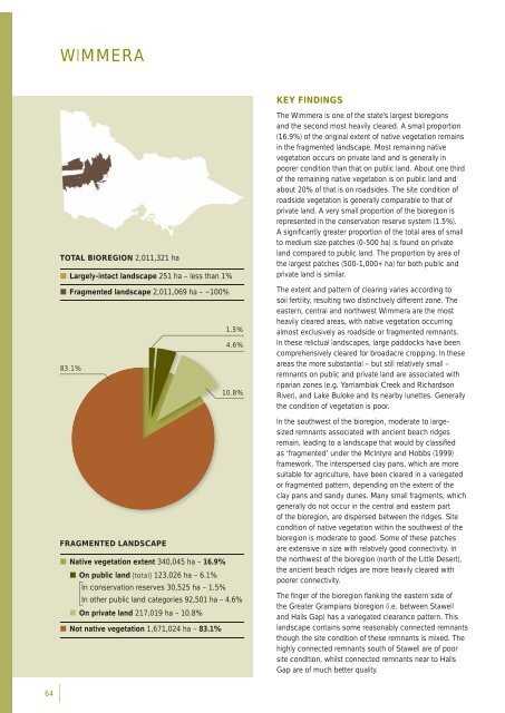
WIMMERAKEY FINDINGSTOTAL BIOREGION 2,011,321 ha• Largely-intact landscape 251 ha – less than 1%• Fragmented landscape 2,011,069 ha – ~100%1.5%4.6%83.1%10.8%FRAGMENTED LANDSCAPE• Native vegetation extent 340,045 ha – 16.9%• On public land [total] 123,026 ha – 6.1%In conservation reserves 30,525 ha – 1.5%In other public land categories 92,501 ha – 4.6%• On private land 217,019 ha – 10.8%• Not native vegetation 1,671,024 ha – 83.1%The Wimmera is one of the state’s largest <strong>bioregion</strong>sand the second most heavily cleared. A small proportion(16.9%) of the original extent of native vegetation remainsin the fragmented landscape. Most remaining nativevegetation occurs on private land and is generally inpoorer condition than that on public land. About one thirdof the remaining native vegetation is on public land andabout 20% of that is on roadsides. The site condition ofroadside vegetation is generally comparable to that ofprivate land. A very small proportion of the <strong>bioregion</strong> isrepresented in the conservation reserve system (1.5%).A signifi cantly greater proportion of the total area of smallto medium size patches (0-500 ha) is found on privateland compared to public land. The proportion <strong>by</strong> area ofthe largest patches (500-1,000+ ha) for both public andprivate land is similar.The extent and pattern of clearing varies according tosoil fertility, resulting two distinctively different zone. Theeastern, central and northwest Wimmera are the mostheavily cleared areas, with native vegetation occurringalmost exclusively as roadside or fragmented remnants.In these relictual landscapes, large paddocks have beencomprehensively cleared for broadacre cropping. In theseareas the more substantial – but still relatively small –remnants on public and private land are associated withriparian zones (e.g. Yarriambiak Creek and RichardsonRiver), and Lake Buloke and its near<strong>by</strong> lunettes. Generallythe condition of vegetation is poor.In the southwest of the <strong>bioregion</strong>, moderate to largesizedremnants associated with ancient beach ridgesremain, leading to a landscape that would <strong>by</strong> classifi edas ‘fragmented’ under the McIntyre and Hobbs (1999)framework. The interspersed clay pans, which are moresuitable for agriculture, have been cleared in a variegatedor fragmented pattern, depending on the extent of theclay pans and sandy dunes. Many small fragments, whichgenerally do not occur in the central and eastern partof the <strong>bioregion</strong>, are dispersed between the ridges. Sitecondition of native vegetation within the southwest of the<strong>bioregion</strong> is moderate to good. Some of these patchesare extensive in size with relatively good connectivity. Inthe northwest of the <strong>bioregion</strong> (north of the Little Desert),the ancient beach ridges are more heavily cleared withpoorer connectivity.The fi nger of the <strong>bioregion</strong> fl anking the eastern side ofthe Greater Grampians <strong>bioregion</strong> (i.e. between Stawelland Halls Gap) has a variegated clearance pattern. Thislandscape contains some reasonably connected remnantsthough the site condition of these remnants is mixed. Thehighly connected remnants south of Stawell are of poorsite condition, whilst connected remnants near to HallsGap are of much better quality.64


