

findings by bioregion - Victorian Environmental Assessment Council
findings by bioregion - Victorian Environmental Assessment Council
findings by bioregion - Victorian Environmental Assessment Council

Create successful ePaper yourself
Turn your PDF publications into a flip-book with our unique Google optimized e-Paper software.
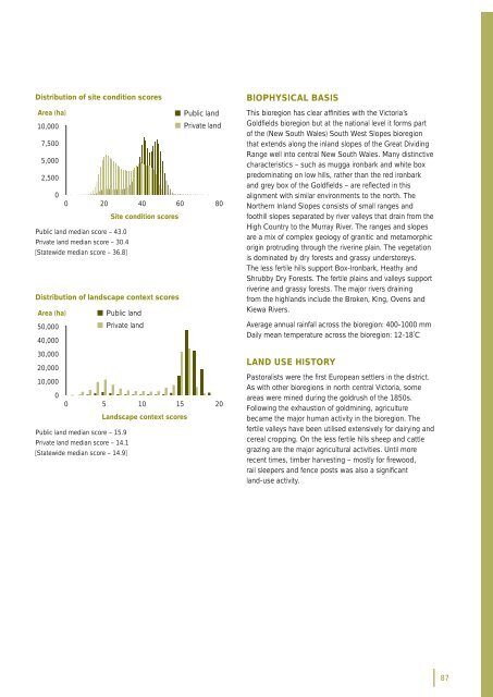
Distribution of site condition scoresArea (ha)• Public land10,000• Private land7,5005,0002,50000 20 40 60 80Site condition scoresPublic land median score – 43.0Private land median score – 30.4[Statewide median score – 36.8]Distribution of landscape context scoresArea (ha) • Public land50,000• Private land40,00030,00020,00010,00000 5 10 15 20Landscape context scoresPublic land median score – 15.9Private land median score – 14.1[Statewide median score – 14.9]BIOPHYSICAL BASISThis <strong>bioregion</strong> has clear affi nities with the Victoria’sGoldfi elds <strong>bioregion</strong> but at the national level it forms partof the (New South Wales) South West Slopes <strong>bioregion</strong>that extends along the inland slopes of the Great DividingRange well into central New South Wales. Many distinctivecharacteristics – such as mugga ironbark and white boxpredominating on low hills, rather than the red ironbarkand grey box of the Goldfi elds – are refl ected in thisalignment with similar environments to the north. TheNorthern Inland Slopes consists of small ranges andfoothill slopes separated <strong>by</strong> river valleys that drain from theHigh Country to the Murray River. The ranges and slopesare a mix of complex geology of granitic and metamorphicorigin protruding through the riverine plain. The vegetationis dominated <strong>by</strong> dry forests and grassy understoreys.The less fertile hills support Box-Ironbark, Heathy andShrub<strong>by</strong> Dry Forests. The fertile plains and valleys supportriverine and grassy forests. The major rivers drainingfrom the highlands include the Broken, King, Ovens andKiewa Rivers.Average annual rainfall across the <strong>bioregion</strong>: 400-1000 mmDaily mean temperature across the <strong>bioregion</strong>: 12-18˚CLAND USE HISTORYPastoralists were the fi rst European settlers in the district.As with other <strong>bioregion</strong>s in north central Victoria, someareas were mined during the goldrush of the 1850s.Following the exhaustion of goldmining, agriculturebecame the major human activity in the <strong>bioregion</strong>. Thefertile valleys have been utilised extensively for dairying andcereal cropping. On the less fertile hills sheep and cattlegrazing are the major agricultural activities. Until morerecent times, timber harvesting – mostly for fi rewood,rail sleepers and fence posts was also a signifi cantland-use activity.87


