

findings by bioregion - Victorian Environmental Assessment Council
findings by bioregion - Victorian Environmental Assessment Council
findings by bioregion - Victorian Environmental Assessment Council

Create successful ePaper yourself
Turn your PDF publications into a flip-book with our unique Google optimized e-Paper software.
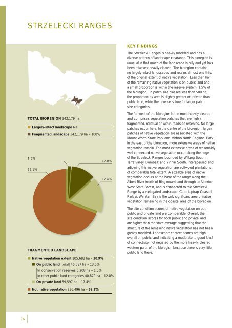
STRZELECKI RANGESTOTAL BIOREGION 342,179 ha• Largely-intact landscape Nil• Fragmented landscape 342,179 ha – 100%1.5%69.1%12.0%17.4%KEY FINDINGSThe Strzelecki Ranges is heavily modifi ed and has adiverse pattern of landscape clearance. This <strong>bioregion</strong> isunusual in that much of the landscape is hilly and yet hasbeen relatively heavily cleared. The <strong>bioregion</strong> containsno largely-intact landscapes and retains almost one thirdof the original extent of native vegetation. Less than halfof the remaining native vegetation is on public land anda small proportion is within the reserve system (1.5% ofthe <strong>bioregion</strong>). In patch size classes less than 500 ha,the proportion <strong>by</strong> area is slightly greater on private thanpublic land, while the reverse is true for larger patchsize categories.The far west of the <strong>bioregion</strong> is the most heavily clearedand comprises vegetation patches that are highlyfragmented, relictual or within roadside reserves. No largepatches occur here. In the centre of the <strong>bioregion</strong>, largerpatches of native vegetation are associated with theMount Worth State Park and Mirboo North Regional Park.In the east of the <strong>bioregion</strong>, more extensive areas of nativevegetation remain. The most extensive areas of reasonablywell connected native vegetation occur along the ridgeof the Strzelecki Ranges bounded <strong>by</strong> Willung South,Tarra Valley, Dumbalk and Yinnar South. Interspersed andadjoining this native vegetation are softwood plantationsof comparable total extent. A sizeable area of nativevegetation occurs at the base of the range along theAlbert River (north of Binginwarri) and through to AlbertonWest State Forest, and is connected to the StrzeleckiRange <strong>by</strong> a variegated landscape. Cape Liptrap CoastalPark at Waratah Bay is the only signifi cant area of nativevegetation remaining in the coastal area of the <strong>bioregion</strong>.FRAGMENTED LANDSCAPE• Native vegetation extent 105,683 ha – 30.9%• On public land [total] 46,087 ha – 13.5%In conservation reserves 5,208 ha – 1.5%In other public land categories 40,879 ha – 12.0%• On private land 59,597 ha – 17.4%The site condition scores of native vegetation on bothpublic and private land are comparable. Overall, thesite condition scores for both public and private landare higher than the state average suggesting that thestructure of the remaining native vegetation has not beengreatly modifi ed. Landscape context scores are highoverall on public land indicating a moderate to good levelof connectivity, not negated <strong>by</strong> the more heavily clearedwestern parts of the <strong>bioregion</strong> because there is very littlepublic land there.• Not native vegetation 236,496 ha – 69.1%76


