

findings by bioregion - Victorian Environmental Assessment Council
findings by bioregion - Victorian Environmental Assessment Council
findings by bioregion - Victorian Environmental Assessment Council

Create successful ePaper yourself
Turn your PDF publications into a flip-book with our unique Google optimized e-Paper software.
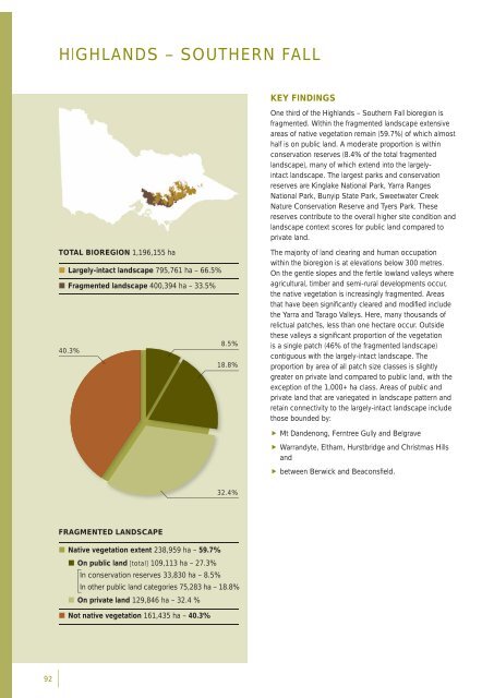
HIGHLANDS – SOUTHERN FALLKEY FINDINGSOne third of the Highlands – Southern Fall <strong>bioregion</strong> isfragmented. Within the fragmented landscape extensiveareas of native vegetation remain (59.7%) of which almosthalf is on public land. A moderate proportion is withinconservation reserves (8.4% of the total fragmentedlandscape), many of which extend into the largelyintactlandscape. The largest parks and conservationreserves are Kinglake National Park, Yarra RangesNational Park, Bunyip State Park, Sweetwater CreekNature Conservation Reserve and Tyers Park. Thesereserves contribute to the overall higher site condition andlandscape context scores for public land compared toprivate land.TOTAL BIOREGION 1,196,155 ha• Largely-intact landscape 795,761 ha – 66.5%• Fragmented landscape 400,394 ha – 33.5%8.5%40.3%18.8%The majority of land clearing and human occupationwithin the <strong>bioregion</strong> is at elevations below 300 metres.On the gentle slopes and the fertile lowland valleys whereagricultural, timber and semi-rural developments occur,the native vegetation is increasingly fragmented. Areasthat have been signifi cantly cleared and modifi ed includethe Yarra and Tarago Valleys. Here, many thousands ofrelictual patches, less than one hectare occur. Outsidethese valleys a signifi cant proportion of the vegetationis a single patch (46% of the fragmented landscape)contiguous with the largely-intact landscape. Theproportion <strong>by</strong> area of all patch size classes is slightlygreater on private land compared to public land, with theexception of the 1,000+ ha class. Areas of public andprivate land that are variegated in landscape pattern andretain connectivity to the largely-intact landscape includethose bounded <strong>by</strong>: Mt Dandenong, Ferntree Gully and Belgrave Warrandyte, Eltham, Hurstbridge and Christmas Hillsand between Berwick and Beaconsfi eld.32.4%FRAGMENTED LANDSCAPE• Native vegetation extent 238,959 ha – 59.7%• On public land [total] 109,113 ha – 27.3%In conservation reserves 33,830 ha – 8.5%In other public land categories 75,283 ha – 18.8%• On private land 129,846 ha – 32.4 %• Not native vegetation 161,435 ha – 40.3%92


