

findings by bioregion - Victorian Environmental Assessment Council
findings by bioregion - Victorian Environmental Assessment Council
findings by bioregion - Victorian Environmental Assessment Council

You also want an ePaper? Increase the reach of your titles
YUMPU automatically turns print PDFs into web optimized ePapers that Google loves.
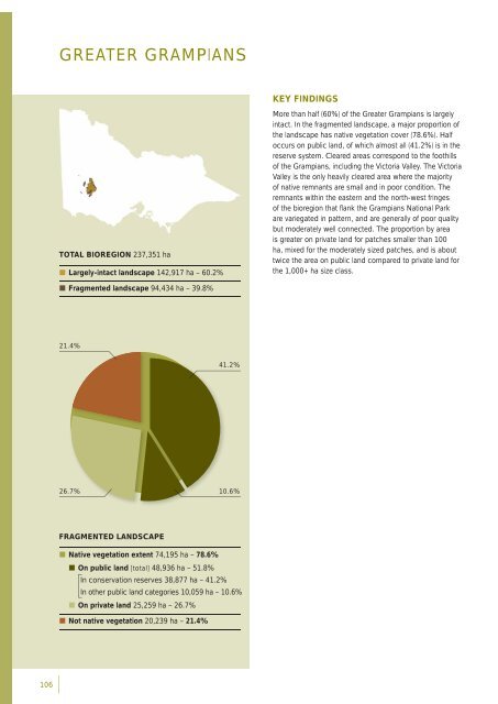
GREATER GRAMPIANSKEY FINDINGSTOTAL BIOREGION 237,351 ha• Largely-intact landscape 142,917 ha – 60.2%More than half (60%) of the Greater Grampians is largelyintact. In the fragmented landscape, a major proportion ofthe landscape has native vegetation cover (78.6%). Halfoccurs on public land, of which almost all (41.2%) is in thereserve system. Cleared areas correspond to the foothillsof the Grampians, including the Victoria Valley. The VictoriaValley is the only heavily cleared area where the majorityof native remnants are small and in poor condition. Theremnants within the eastern and the north-west fringesof the <strong>bioregion</strong> that fl ank the Grampians National Parkare variegated in pattern, and are generally of poor qualitybut moderately well connected. The proportion <strong>by</strong> areais greater on private land for patches smaller than 100ha, mixed for the moderately sized patches, and is abouttwice the area on public land compared to private land forthe 1,000+ ha size class.• Fragmented landscape 94,434 ha – 39.8%21.4%41.2%26.7%10.6%FRAGMENTED LANDSCAPE• Native vegetation extent 74,195 ha – 78.6%• On public land [total] 48,936 ha – 51.8%In conservation reserves 38,877 ha – 41.2%In other public land categories 10,059 ha – 10.6%• On private land 25,259 ha – 26.7%• Not native vegetation 20,239 ha – 21.4%106


