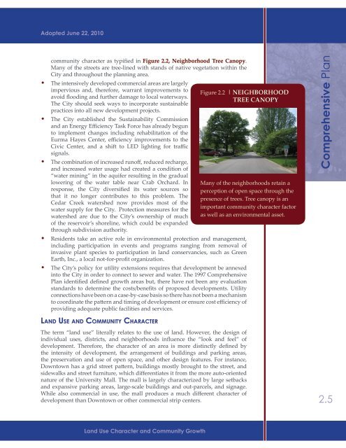
Adopted June 22, 2010community character as typified in Figure 2.2, Neighborhood Tree Canopy.Many of the streets are tree-lined with stands of native vegetation within theCity and throughout the planning area.• The intensively developed commercial areas are largelyimpervious and, therefore, warrant improvements toavoid flooding and further damage to local waterways.The City should seek ways to incorporate sustainablepractices into all new development projects.• The City established the Sustainability Commissionand an Energy Efficiency Task Force has already begunto implement changes including rehabilitation of theEurma Hayes Center, efficiency improvements to theCivic Center, and a shift to LED lighting for trafficsignals.• The combination of increased runoff, reduced recharge,and increased water usage had created a condition of“water mining” in the aquifer resulting in the graduallowering of the water table near Crab Orchard. Inresponse, the City diversified its water sources sothat it no longer contributes to this problem. TheCedar Creek watershed now provides most of thewater supply for the City. Protection measures for thewatershed are due to the City’s ownership of muchof the reservoir’s shoreline, which could be expandedthrough subdivision authority.• Residents take an active role in environmental protection and management,including participation in events and programs ranging from removal ofinvasive plant species to participation in land conservancies, such as GreenEarth, Inc., a local not-for-profit organization.• The City’s policy for utility extensions requires that development be annexedinto the City in order to connect to sewer and water. The 1997 <strong>Comprehensive</strong><strong>Plan</strong> identified defined growth areas but, there have not been any evaluationstandards to determine the costs/benefits of proposed developments. Utilityconnections have been on a case-by-case basis so there has not been a mechanismto coordinate the pattern and timing of development or ensure cost efficiency ofproviding adequate public facilities and services.Figure 2.2 | NEIGHBORHOODTREE CANOPYMany of the neighborhoods retain aperception of open space through thepresence of trees. Tree canopy is animportant community character factoras well as an environmental asset.<strong>Comprehensive</strong> <strong>Plan</strong>Land Use and Community CharacterThe term “land use” literally relates to the use of land. However, the design ofindividual uses, districts, and neighborhoods influence the “look and feel” ofdevelopment. Therefore, the character of an area is more distinctly defined bythe intensity of development, the arrangement of buildings and parking areas,the preservation and use of open space, and other design features. For instance,Downtown has a grid street pattern, buildings mostly brought to the street, andsidewalks and street furniture, which differentiates it from the more auto-orientednature of the University Mall. The mall is largely characterized by large setbacksand expansive parking areas, large-scale buildings and out-parcels, and signage.While also commercial in use, the mall produces a much different character ofdevelopment than Downtown or other commercial strip centers.2.5Land Use Character and Community Growth
Adopted June 22, 2010City of <strong>Carbondale</strong>2.6It is this combination of land use and design that determine the compatibility andquality of development. Aesthetic enhancements, such as the design of buildings,landscaping and screening, sign control, and site amenities, also contribute to theappeal of <strong>Carbondale</strong>. It is each of the above considerations that collectively areresponsible for the community’s character and appearance and the impressions lefton visitors and passers-by.Examples of how design influences character within different land use typesinclude:• a single-family home situated on a large lot with mature trees and separatedfrom neighboring homes versus a detached single-family home on a small lotwith rear-alley access and minimal yard space and vegetation;• a master-planned business park in a campus-like setting versus an officebuilding on an individual site surrounded by a parking lot;• storefront shops and small cafes in a walkable, neighborhood setting versus“big box” stores and pad-site restaurants and retailers in a large-scale shoppingcenter with expansive surface parking and minimal landscaping; and• a manufacturing facility that is nestled on a largeFigure 2.3 | ZONING ORDINANCESTANDARDSThe recent destruction of a local businessrequired that it be reconstructedaccording to the new Downtown zoningregulations. Improvements in the zoningstandards lead to changes on the groundthat can be visible to residents.site and among broad open space and mature treesand landscaping versus a more intensive industrialoperation with outdoor activity and unscreenedequipment storage.Above are examples of the same use types that mayassume different characters depending on their layout,design, and environmental context.The zoning ordinance plays a significant role inestablishing the physical character of the community.After all, this ordinance determines the types of use anddelineation of districts, together with the height andarea requirements and standards for landscaping, openspace, and signage. As a result, the zoning ordinancelargely directs the development outcomes as highlightedin Figure 2.3, Zoning Ordinance Standards. This isimportant since it provides a regulatory context inwhich local land use decisions may be made to foster asustainable environment, a prosperous economy, and ahigh quality of life. The City’s development ordinances(zoning, subdivision, sign, landscaping, and buildingcodes) represent the primary tools for implementing therecommendations in this document.Examined in this chapter is the basic use of land,together with the standards and elements of designthat lead to the appearance of neighborhoods, commercial areas, and corridors,and the compatibility among and between them. This includes such factors asdensity, intensity, building setbacks, height and lot coverage, amount of open space,and vegetation. Since the zoning and subdivision regulations direct the design ofindividual sites, they warrant special attention. However, there are many other“levers” that can be utilized to create appropriate development and encourageattractive redevelopment of existing sites. These tools must be fully utilized so thatfuture development reflects the aspirations of <strong>Carbondale</strong> residents.Chapter Two
- Page 1: Adopted June 22, 2010
- Page 4 and 5: Adopted June 22, 2010City of Carbon
- Page 6 and 7: Adopted June 22, 2010City of Carbon
- Page 8 and 9: Adopted June 22, 20101CommunityOver
- Page 10 and 11: Adopted June 22, 2010validates many
- Page 12 and 13: DemographicComparisonEducation% Pop
- Page 14 and 15: Adopted June 22, 2010will remain st
- Page 16 and 17: Adopted June 22, 2010factors for re
- Page 18 and 19: Adopted June 22, 2010strategies, in
- Page 20 and 21: Adopted June 22, 2010To facilitate
- Page 22 and 23: Adopted June 22, 2010A priority-set
- Page 24 and 25: Adopted June 22, 2010Infill Develop
- Page 26 and 27: Adopted June 22, 2010the community
- Page 28 and 29: 2Land Use CharacterAdopted June 22,
- Page 30 and 31: Adopted June 22, 2010• Strategy 3
- Page 34 and 35: Adopted June 22, 2010DesignationTab
- Page 36 and 37: Adopted June 22, 2010Summary of exi
- Page 38 and 39: Adopted June 22, 2010a priority (al
- Page 40 and 41: Adopted June 22, 2010Park Service A
- Page 42 and 43: Adopted June 22, 2010area (see Map
- Page 44 and 45: Adopted June 22, 2010environmental
- Page 46 and 47: Adopted June 22, 2010as a valuable
- Page 48 and 49: Adopted June 22, 2010c. Improve acc
- Page 50 and 51: Adopted June 22, 2010District / Dev
- Page 52 and 53: Adopted June 22, 2010Actions and In
- Page 54 and 55: Adopted June 22, 2010The “communi
- Page 56 and 57: Adopted June 22, 2010Actions and In
- Page 58 and 59: Adopted June 22, 2010building place
- Page 60 and 61: Adopted June 22, 2010during the lat
- Page 62 and 63: Adopted June 22, 2010Plan. This dis
- Page 64 and 65: Adopted June 22, 2010monotony by re
- Page 66 and 67: Adopted June 22, 2010g. Amend the c
- Page 68 and 69: Adopted June 22, 2010effective in a
- Page 70 and 71: AIRPORT RDService2.2ParkAreasPARKS
- Page 72 and 73: COUNTRY CLUB RDS. OAKLAND AVEMurphy
- Page 75 and 76: Adopted June 22, 20103CommunityMobi
- Page 77 and 78: Adopted June 22, 20103.3 Existing C
- Page 79 and 80: Adopted June 22, 2010Existing Stree
- Page 81 and 82: Adopted June 22, 2010caused by turn
- Page 83 and 84:
Adopted June 22, 2010secondary arte
- Page 85 and 86:
Adopted June 22, 2010of traffic sig
- Page 87 and 88:
Adopted June 22, 2010number and wid
- Page 89 and 90:
Adopted June 22, 2010e. Coordinate
- Page 91 and 92:
Adopted June 22, 2010STREETSCAPE MA
- Page 93 and 94:
Adopted June 22, 2010c. Re-evaluate
- Page 95 and 96:
Adopted June 22, 2010streets’ imp
- Page 97 and 98:
Adopted June 22, 2010Downtown Carbo
- Page 99 and 100:
COUNTRY CLUB RDN. BILLY BRYAN STS.
- Page 101 and 102:
3.3SalukiExpress RoutesTRANSIT ROUT
- Page 103 and 104:
Adopted June 22, 20104Housing &Neig
- Page 105 and 106:
Adopted June 22, 2010Summary of Hou
- Page 107 and 108:
Adopted June 22, 2010the 1970’s.
- Page 109 and 110:
Adopted June 22, 2010Figure 4.3 | O
- Page 111 and 112:
Adopted June 22, 2010units. This su
- Page 113 and 114:
Adopted June 22, 2010poverty, conve
- Page 115 and 116:
Adopted June 22, 2010from increased
- Page 117 and 118:
Adopted June 22, 2010Rationale:In s
- Page 119 and 120:
Adopted June 22, 2010Strategy 2: Ut
- Page 121 and 122:
Adopted June 22, 2010building orien
- Page 123 and 124:
Adopted June 22, 2010Table 4.5Incom
- Page 125 and 126:
Adopted June 22, 2010including publ
- Page 127 and 128:
COUNTRY CLUB RDN. MARION STBig Mudd
- Page 129 and 130:
Big Muddy R.104.03Big Muddy R.Crab
- Page 131 and 132:
COUNTRY CLUB RDN. MARION STMurphysb
- Page 133 and 134:
Adopted June 22, 2010City of Carbon
- Page 135 and 136:
Adopted June 22, 2010City of Carbon
- Page 137 and 138:
Adopted June 22, 2010City of Carbon
- Page 139 and 140:
Adopted June 22, 2010City of Carbon
- Page 141 and 142:
Adopted June 22, 2010City of Carbon
- Page 143 and 144:
Adopted June 22, 2010City of Carbon
- Page 145 and 146:
Adopted June 22, 2010City of Carbon
- Page 147 and 148:
Adopted June 22, 2010City of Carbon
- Page 149 and 150:
Adopted June 22, 2010City of Carbon
- Page 151 and 152:
Adopted June 22, 2010City of Carbon
- Page 153 and 154:
Adopted June 22, 2010City of Carbon
- Page 155 and 156:
Adopted June 22, 2010City of Carbon
- Page 157 and 158:
Adopted June 22, 2010City of Carbon
- Page 159 and 160:
Adopted June 22, 2010City of Carbon
- Page 161 and 162:
Adopted June 22, 2010City of Carbon
- Page 163 and 164:
Adopted June 22, 2010City of Carbon
- Page 165 and 166:
Adopted June 22, 2010City of Carbon