Adopted June 22, 2010City of <strong>Carbondale</strong>Of relevance to this plan is the management of property access along each ofthe arterial roadways. Driveway access to arterial roads slows traffic and createspotential points of conflict. The numbers of access points affect the operatingefficiency of the street system. Solutions to this problem include shared access toreduce the number of breaks in traffic; cross access easements to move vehiclesbetween properties without accessing the arterial street; and, in feasible locations,boulevard street sections.Strategy 1: Improve continuity of the street system to provide connectionswithin and between neighborhoods and districts.RationaleThe majority of the City’s older residential areas are on a grid system providing goodconnectivity within and through neighborhoods. However, newer neighborhoodsin the periphery have been designed with a curvilinear street pattern, cul-de-sacs,and, often, one point of entry/exit. While this pattern is desirable by residentsfor reasons of safety and aesthetics, concerns are typically raised regardingconnectivity. Also, as new subdivisions are developed, plans should be madefor adequate connectivity within and between neighborhoods. New subdivisionsand commercial centers should be developed in a manner that allows multipletransportation options. It is not sufficient to simply designate where new corridorswill expand, but there is much gained or lost in the manner of their development.A well-designed, multi-modal corridor can be a boon to a neighborhood, while apoorly designed street may only signal a lost opportunity.3.10Actions and Initiativesa. Amend the subdivision regulations to include more provisions that standardizeconnectivity and discourage one-way in/one-way out subdivisions. Connectivityimprovements may include requiring street connectivity between subdivisionsand more than one point of access for subdivisions over twenty lots.b. Adopt a policy requiring the extension of collectors to and through a newsubdivision (similar to utilities).c. Create a new railroad crossing at Sycamore Street and consider closing anexisting crossing.d. Improve citywide mobility, including better north-south and east-west accessvia local roadways. Current transportation patterns use <strong>IL</strong> 13 and U.S. 51as the primary means of cross-town circulation due to the lack of parallelroadway alternatives. The City can overcome these barriers to street continuitythrough right-of-way acquisition and community investments as listed on theThoroughfare <strong>Plan</strong>.e. Consider as potential community investment projects the extension of collectorstreets in developing areas. Sycamore Street, or Oak Street, between Wall Streetand Lewis Lane, for example, is a project that will alleviate traffic on otherlocal streets and greatly improve the mobility in the adjacent neighborhoods.Another collector roadway connection might include Rigdon Street, betweenNew Era Road and Oakland Avenue. Projects of this nature, however, must besensitive in their design.f. Conduct transportation demand management (TDM) and transportationsystems management (TSM) studies and improvement projects for U.S. 51, <strong>IL</strong> 13,and other applicable roadways. These strategies may include synchronizationChapter Three
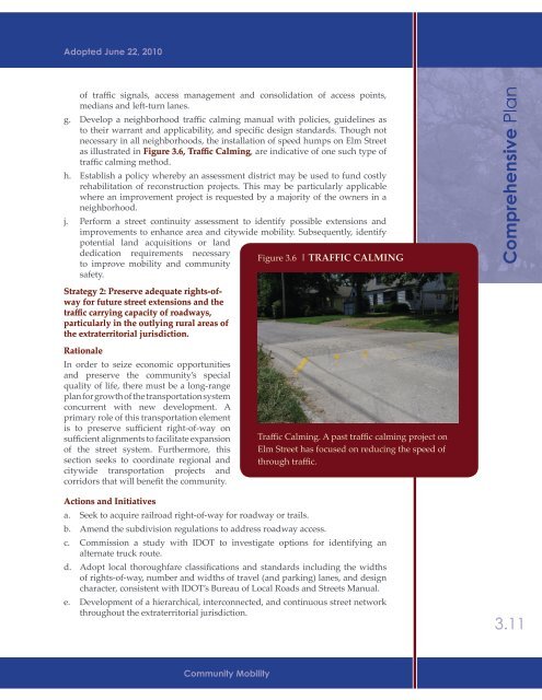
Adopted June 22, 2010of traffic signals, access management and consolidation of access points,medians and left-turn lanes.g. Develop a neighborhood traffic calming manual with policies, guidelines asto their warrant and applicability, and specific design standards. Though notnecessary in all neighborhoods, the installation of speed humps on Elm Streetas illustrated in Figure 3.6, Traffic Calming, are indicative of one such type oftraffic calming method.h. Establish a policy whereby an assessment district may be used to fund costlyrehabilitation of reconstruction projects. This may be particularly applicablewhere an improvement project is requested by a majority of the owners in aneighborhood.j. Perform a street continuity assessment to identify possible extensions andimprovements to enhance area and citywide mobility. Subsequently, identifypotential land acquisitions or landdedication requirements necessaryFigure 3.6 | TRAFFIC CALMINGto improve mobility and communitysafety.Strategy 2: Preserve adequate rights-ofwayfor future street extensions and thetraffic carrying capacity of roadways,particularly in the outlying rural areas ofthe extraterritorial jurisdiction.RationaleIn order to seize economic opportunitiesand preserve the community’s specialquality of life, there must be a long-rangeplan for growth of the transportation systemconcurrent with new development. Aprimary role of this transportation elementis to preserve sufficient right-of-way onsufficient alignments to facilitate expansionof the street system. Furthermore, thissection seeks to coordinate regional andcitywide transportation projects andcorridors that will benefit the community.Traffic Calming. A past traffic calming project onElm Street has focused on reducing the speed ofthrough traffic.<strong>Comprehensive</strong> <strong>Plan</strong>Actions and Initiativesa. Seek to acquire railroad right-of-way for roadway or trails.b. Amend the subdivision regulations to address roadway access.c. Commission a study with IDOT to investigate options for identifying analternate truck route.d. Adopt local thoroughfare classifications and standards including the widthsof rights-of-way, number and widths of travel (and parking) lanes, and designcharacter, consistent with IDOT’s Bureau of Local Roads and Streets Manual.e. Development of a hierarchical, interconnected, and continuous street networkthroughout the extraterritorial jurisdiction.3.11Community Mobility
- Page 1:
Adopted June 22, 2010
- Page 4 and 5:
Adopted June 22, 2010City of Carbon
- Page 6 and 7:
Adopted June 22, 2010City of Carbon
- Page 8 and 9:
Adopted June 22, 20101CommunityOver
- Page 10 and 11:
Adopted June 22, 2010validates many
- Page 12 and 13:
DemographicComparisonEducation% Pop
- Page 14 and 15:
Adopted June 22, 2010will remain st
- Page 16 and 17:
Adopted June 22, 2010factors for re
- Page 18 and 19:
Adopted June 22, 2010strategies, in
- Page 20 and 21:
Adopted June 22, 2010To facilitate
- Page 22 and 23:
Adopted June 22, 2010A priority-set
- Page 24 and 25:
Adopted June 22, 2010Infill Develop
- Page 26 and 27:
Adopted June 22, 2010the community
- Page 28 and 29:
2Land Use CharacterAdopted June 22,
- Page 30 and 31:
Adopted June 22, 2010• Strategy 3
- Page 32 and 33:
Adopted June 22, 2010community char
- Page 34 and 35: Adopted June 22, 2010DesignationTab
- Page 36 and 37: Adopted June 22, 2010Summary of exi
- Page 38 and 39: Adopted June 22, 2010a priority (al
- Page 40 and 41: Adopted June 22, 2010Park Service A
- Page 42 and 43: Adopted June 22, 2010area (see Map
- Page 44 and 45: Adopted June 22, 2010environmental
- Page 46 and 47: Adopted June 22, 2010as a valuable
- Page 48 and 49: Adopted June 22, 2010c. Improve acc
- Page 50 and 51: Adopted June 22, 2010District / Dev
- Page 52 and 53: Adopted June 22, 2010Actions and In
- Page 54 and 55: Adopted June 22, 2010The “communi
- Page 56 and 57: Adopted June 22, 2010Actions and In
- Page 58 and 59: Adopted June 22, 2010building place
- Page 60 and 61: Adopted June 22, 2010during the lat
- Page 62 and 63: Adopted June 22, 2010Plan. This dis
- Page 64 and 65: Adopted June 22, 2010monotony by re
- Page 66 and 67: Adopted June 22, 2010g. Amend the c
- Page 68 and 69: Adopted June 22, 2010effective in a
- Page 70 and 71: AIRPORT RDService2.2ParkAreasPARKS
- Page 72 and 73: COUNTRY CLUB RDS. OAKLAND AVEMurphy
- Page 75 and 76: Adopted June 22, 20103CommunityMobi
- Page 77 and 78: Adopted June 22, 20103.3 Existing C
- Page 79 and 80: Adopted June 22, 2010Existing Stree
- Page 81 and 82: Adopted June 22, 2010caused by turn
- Page 83: Adopted June 22, 2010secondary arte
- Page 87 and 88: Adopted June 22, 2010number and wid
- Page 89 and 90: Adopted June 22, 2010e. Coordinate
- Page 91 and 92: Adopted June 22, 2010STREETSCAPE MA
- Page 93 and 94: Adopted June 22, 2010c. Re-evaluate
- Page 95 and 96: Adopted June 22, 2010streets’ imp
- Page 97 and 98: Adopted June 22, 2010Downtown Carbo
- Page 99 and 100: COUNTRY CLUB RDN. BILLY BRYAN STS.
- Page 101 and 102: 3.3SalukiExpress RoutesTRANSIT ROUT
- Page 103 and 104: Adopted June 22, 20104Housing &Neig
- Page 105 and 106: Adopted June 22, 2010Summary of Hou
- Page 107 and 108: Adopted June 22, 2010the 1970’s.
- Page 109 and 110: Adopted June 22, 2010Figure 4.3 | O
- Page 111 and 112: Adopted June 22, 2010units. This su
- Page 113 and 114: Adopted June 22, 2010poverty, conve
- Page 115 and 116: Adopted June 22, 2010from increased
- Page 117 and 118: Adopted June 22, 2010Rationale:In s
- Page 119 and 120: Adopted June 22, 2010Strategy 2: Ut
- Page 121 and 122: Adopted June 22, 2010building orien
- Page 123 and 124: Adopted June 22, 2010Table 4.5Incom
- Page 125 and 126: Adopted June 22, 2010including publ
- Page 127 and 128: COUNTRY CLUB RDN. MARION STBig Mudd
- Page 129 and 130: Big Muddy R.104.03Big Muddy R.Crab
- Page 131 and 132: COUNTRY CLUB RDN. MARION STMurphysb
- Page 133 and 134: Adopted June 22, 2010City of Carbon
- Page 135 and 136:
Adopted June 22, 2010City of Carbon
- Page 137 and 138:
Adopted June 22, 2010City of Carbon
- Page 139 and 140:
Adopted June 22, 2010City of Carbon
- Page 141 and 142:
Adopted June 22, 2010City of Carbon
- Page 143 and 144:
Adopted June 22, 2010City of Carbon
- Page 145 and 146:
Adopted June 22, 2010City of Carbon
- Page 147 and 148:
Adopted June 22, 2010City of Carbon
- Page 149 and 150:
Adopted June 22, 2010City of Carbon
- Page 151 and 152:
Adopted June 22, 2010City of Carbon
- Page 153 and 154:
Adopted June 22, 2010City of Carbon
- Page 155 and 156:
Adopted June 22, 2010City of Carbon
- Page 157 and 158:
Adopted June 22, 2010City of Carbon
- Page 159 and 160:
Adopted June 22, 2010City of Carbon
- Page 161 and 162:
Adopted June 22, 2010City of Carbon
- Page 163 and 164:
Adopted June 22, 2010City of Carbon
- Page 165 and 166:
Adopted June 22, 2010City of Carbon