October 2011 Bassetlaw District Local Development Framework
October 2011 Bassetlaw District Local Development Framework
October 2011 Bassetlaw District Local Development Framework
- No tags were found...

You also want an ePaper? Increase the reach of your titles
YUMPU automatically turns print PDFs into web optimized ePapers that Google loves.
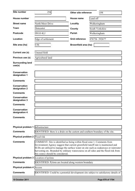
Site number 294 Other site reference ii98House number House name Land offStreet name North Moor Drive <strong>Local</strong>ity WalkeringhamTown Doncaster County South YorkshirePostcode DN10 4LJ Parish WalkeringhamLocation Edge of settlement Grid reference 476736 392677Site area (ha) 0.96 Brownfield area (ha)Current use (s)Previous use (s)Unused fieldAgricultural landSurrounding landuse(s)Conservationdesignation 1CommentsConservationdesignation 2CommentsConservationdesignation 3CommentsConservationdesignation 4CommentsPhysical problem 1 InfrastructureCommentsIDENTIFIED: there is a drain on the eastern and southern boundary of the site.Physical problem 2 Flood riskCommentsPhysical problem 3 Location of pylonsCommentsPhysical problem 4 AccessCOMMENT: Site is identified as being within flood zone 1. Comments fromEnvironment Agency suggest that current greenfield runoff rate is maintained andSUDs are utilised to manage the surface water on site such as soakaways or rainwaterharvesting etc. Bounded by ordinary watercourse on all sides and the flood risk fromthis source should be considered.IDENTIFIED: Pylons are located along western boundaryCommentsIDENTIFIED: Could be a potential development site subject to satisfactory details of19 <strong>October</strong> <strong>2011</strong> Page 878 of 1704