October 2011 Bassetlaw District Local Development Framework
October 2011 Bassetlaw District Local Development Framework
October 2011 Bassetlaw District Local Development Framework
- No tags were found...

Create successful ePaper yourself
Turn your PDF publications into a flip-book with our unique Google optimized e-Paper software.
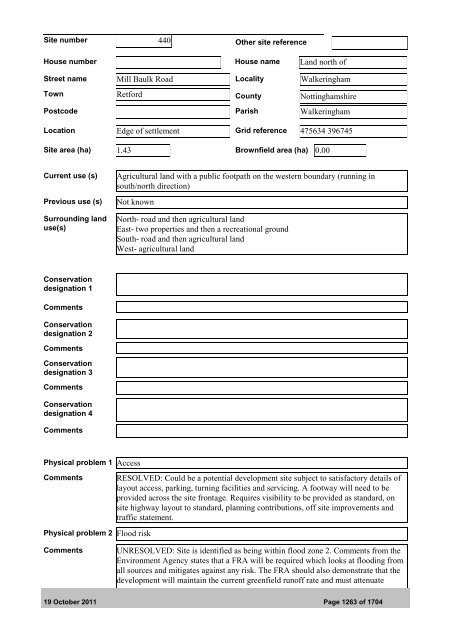
Site number 440 Other site referenceHouse number House name Land north ofStreet name Mill Baulk Road <strong>Local</strong>ity WalkeringhamTown Retford County NottinghamshirePostcode Parish WalkeringhamLocation Edge of settlement Grid reference 475634 396745Site area (ha) 1.43 Brownfield area (ha) 0.00Current use (s)Previous use (s)Surrounding landuse(s)Agricultural land with a public footpath on the western boundary (running insouth/north direction)Not knownNorth- road and then agricultural landEast- two properties and then a recreational groundSouth- road and then agricultural landWest- agricultural landConservationdesignation 1CommentsConservationdesignation 2CommentsConservationdesignation 3CommentsConservationdesignation 4CommentsPhysical problem 1 AccessCommentsPhysical problem 2 Flood riskRESOLVED: Could be a potential development site subject to satisfactory details oflayout access, parking, turning facilities and servicing. A footway will need to beprovided across the site frontage. Requires visibility to be provided as standard, onsite highway layout to standard, planning contributions, off site improvements andtraffic statement.CommentsUNRESOLVED: Site is identified as being within flood zone 2. Comments from theEnvironment Agency states that a FRA will be required which looks at flooding fromall sources and mitigates against any risk. The FRA should also demonstrate that thedevelopment will maintain the current greenfield runoff rate and must attenuate19 <strong>October</strong> <strong>2011</strong> Page 1263 of 1704