October 2011 Bassetlaw District Local Development Framework
October 2011 Bassetlaw District Local Development Framework
October 2011 Bassetlaw District Local Development Framework
- No tags were found...

Create successful ePaper yourself
Turn your PDF publications into a flip-book with our unique Google optimized e-Paper software.
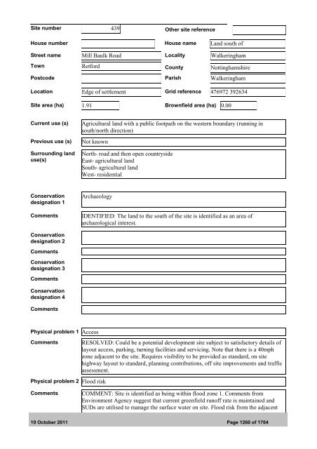
Site number 439 Other site referenceHouse number House name Land south ofStreet name Mill Baulk Road <strong>Local</strong>ity WalkeringhamTown Retford County NottinghamshirePostcode Parish WalkeringhamLocation Edge of settlement Grid reference 476972 392634Site area (ha) 1.91 Brownfield area (ha) 0.00Current use (s)Previous use (s)Surrounding landuse(s)Agricultural land with a public footpath on the western boundary (running insouth/north direction)Not knownNorth- road and then open countrysideEast- agricultural landSouth- agricultural landWest- residentialConservationdesignation 1CommentsArchaeologyIDENTIFIED: The land to the south of the site is identified as an area ofarchaeological interest.Conservationdesignation 2CommentsConservationdesignation 3CommentsConservationdesignation 4CommentsPhysical problem 1 AccessCommentsPhysical problem 2 Flood riskRESOLVED: Could be a potential development site subject to satisfactory details oflayout access, parking, turning facilities and servicing. Note that there is a 40mphzone adjacent to the site. Requires visibility to be provided as standard, on sitehighway layout to standard, planning contributions, off site improvements and trafficassessment.CommentsCOMMENT: Site is identified as being within flood zone 1. Comments fromEnvironment Agency suggest that current greenfield runoff rate is maintained andSUDs are utilised to manage the surface water on site. Flood risk from the adjacent19 <strong>October</strong> <strong>2011</strong> Page 1260 of 1704