October 2011 Bassetlaw District Local Development Framework
October 2011 Bassetlaw District Local Development Framework
October 2011 Bassetlaw District Local Development Framework
- No tags were found...

Create successful ePaper yourself
Turn your PDF publications into a flip-book with our unique Google optimized e-Paper software.
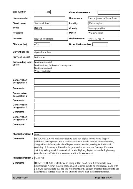
Site number 441 Other site referenceHouse number House name Land adjacent to Home FarmStreet name Stockwith Road <strong>Local</strong>ity WalkeringhamTown Retford County NottinghamshirePostcode Parish WalkeringhamLocation Edge of settlement Grid reference 477478 392577Site area (ha) 0.78 Brownfield area (ha)Current use (s)Previous use (s)Surrounding landuse(s)Agricultural landNot knownNorth- residentialNortheast and East- open countrysideSouth- residentialWest- residentialConservationdesignation 1CommentsConservationdesignation 2CommentsConservationdesignation 3CommentsConservationdesignation 4CommentsPhysical problem 1 AccessCommentsRESOLVED: A161 junction visibility does not appear to be able to supportadditional development, and a traffic assessment would need to show otherwise,along with satisfactory details of layout access, parking, turning facilities andservicing. A footway will need to be provided across the site frontage. Requiresvisibility to be provided as standard, on site highway layout to standard, planningcontributions, off site improvements and traffic assessment.Physical problem 2 Flood riskCommentsIDENTIFIED: Site is identified as being within flood zone 1. Comments fromEnvironment Agency suggest that a phased scheme should be considered, along witha FRA to demonstrate that the site will maintain the current greenfield runoff rate andcan attenuate surface water on site utilising SUDS over the different phases.19 <strong>October</strong> <strong>2011</strong> Page 1266 of 1704