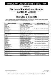
October 2011 Bassetlaw District Local Development Framework
October 2011 Bassetlaw District Local Development Framework
October 2011 Bassetlaw District Local Development Framework
- No tags were found...

You also want an ePaper? Increase the reach of your titles
YUMPU automatically turns print PDFs into web optimized ePapers that Google loves.
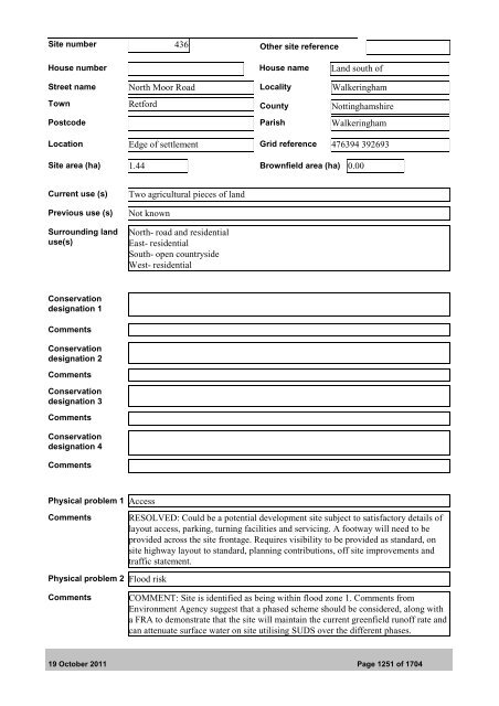
Site number 436 Other site referenceHouse number House name Land south ofStreet name North Moor Road <strong>Local</strong>ity WalkeringhamTown Retford County NottinghamshirePostcode Parish WalkeringhamLocation Edge of settlement Grid reference 476394 392693Site area (ha) 1.44 Brownfield area (ha) 0.00Current use (s)Previous use (s)Surrounding landuse(s)Two agricultural pieces of landNot knownNorth- road and residentialEast- residentialSouth- open countrysideWest- residentialConservationdesignation 1CommentsConservationdesignation 2CommentsConservationdesignation 3CommentsConservationdesignation 4CommentsPhysical problem 1 AccessCommentsRESOLVED: Could be a potential development site subject to satisfactory details oflayout access, parking, turning facilities and servicing. A footway will need to beprovided across the site frontage. Requires visibility to be provided as standard, onsite highway layout to standard, planning contributions, off site improvements andtraffic statement.Physical problem 2 Flood riskCommentsCOMMENT: Site is identified as being within flood zone 1. Comments fromEnvironment Agency suggest that a phased scheme should be considered, along witha FRA to demonstrate that the site will maintain the current greenfield runoff rate andcan attenuate surface water on site utilising SUDS over the different phases.19 <strong>October</strong> <strong>2011</strong> Page 1251 of 1704