October 2011 Bassetlaw District Local Development Framework
October 2011 Bassetlaw District Local Development Framework
October 2011 Bassetlaw District Local Development Framework
- No tags were found...

Create successful ePaper yourself
Turn your PDF publications into a flip-book with our unique Google optimized e-Paper software.
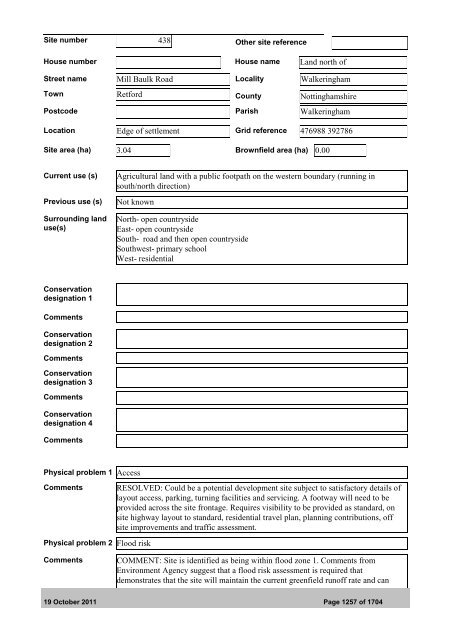
Site number 438 Other site referenceHouse number House name Land north ofStreet name Mill Baulk Road <strong>Local</strong>ity WalkeringhamTown Retford County NottinghamshirePostcode Parish WalkeringhamLocation Edge of settlement Grid reference 476988 392786Site area (ha) 3.04 Brownfield area (ha) 0.00Current use (s)Previous use (s)Surrounding landuse(s)Agricultural land with a public footpath on the western boundary (running insouth/north direction)Not knownNorth- open countrysideEast- open countrysideSouth- road and then open countrysideSouthwest- primary schoolWest- residentialConservationdesignation 1CommentsConservationdesignation 2CommentsConservationdesignation 3CommentsConservationdesignation 4CommentsPhysical problem 1 AccessCommentsPhysical problem 2 Flood riskRESOLVED: Could be a potential development site subject to satisfactory details oflayout access, parking, turning facilities and servicing. A footway will need to beprovided across the site frontage. Requires visibility to be provided as standard, onsite highway layout to standard, residential travel plan, planning contributions, offsite improvements and traffic assessment.CommentsCOMMENT: Site is identified as being within flood zone 1. Comments fromEnvironment Agency suggest that a flood risk assessment is required thatdemonstrates that the site will maintain the current greenfield runoff rate and can19 <strong>October</strong> <strong>2011</strong> Page 1257 of 1704