October 2011 Bassetlaw District Local Development Framework
October 2011 Bassetlaw District Local Development Framework
October 2011 Bassetlaw District Local Development Framework
- No tags were found...

Create successful ePaper yourself
Turn your PDF publications into a flip-book with our unique Google optimized e-Paper software.
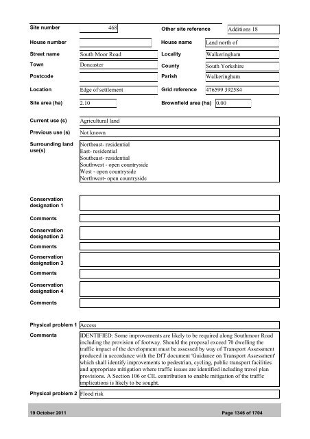
Site number 468 Other site reference Additions 18House number House name Land north ofStreet name South Moor Road <strong>Local</strong>ity WalkeringhamTown Doncaster County South YorkshirePostcode Parish WalkeringhamLocation Edge of settlement Grid reference 476599 392584Site area (ha) 2.10 Brownfield area (ha) 0.00Current use (s)Previous use (s)Surrounding landuse(s)Agricultural landNot knownNortheast- residentialEast- residentialSoutheast- residentialSouthwest - open countrysideWest - open countrysideNorthwest- open countrysideConservationdesignation 1CommentsConservationdesignation 2CommentsConservationdesignation 3CommentsConservationdesignation 4CommentsPhysical problem 1 AccessCommentsPhysical problem 2 Flood riskIDENTIFIED: Some improvements are likely to be required along Southmoor Roadincluding the provision of footway. Should the proposal exceed 70 dwelling thetraffic impact of the development must be assessed by way of Transport Assessmentproduced in accordance with the DfT document 'Guidance on Transport Assessment'which shall identify improvements to pedestrian, cycling, public transport facilitiesand appropriate mitigation where traffic issues are identified including travel planprovisions. A Section 106 or CIL contribution to enable mitigation of the trafficimplications is likely to be sought.19 <strong>October</strong> <strong>2011</strong> Page 1346 of 1704