October 2011 Bassetlaw District Local Development Framework
October 2011 Bassetlaw District Local Development Framework
October 2011 Bassetlaw District Local Development Framework
- No tags were found...

You also want an ePaper? Increase the reach of your titles
YUMPU automatically turns print PDFs into web optimized ePapers that Google loves.
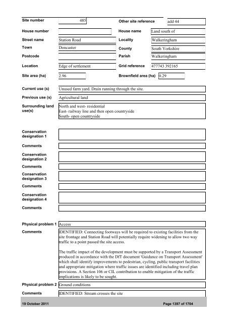
Site number 485 Other site reference add 44House number House name Land south ofStreet name Station Road <strong>Local</strong>ity WalkeringhamTown Doncaster County South YorkshirePostcode Parish WalkeringhamLocation Edge of settlement Grid reference 477743 392165Site area (ha) 2.96 Brownfield area (ha) 0.29Current use (s)Previous use (s)Surrounding landuse(s)Unused farm yard. Drain running through the site.Agricultural landNorth and west- residentialEast- railway line and then open countrysideSouth- open countrysideConservationdesignation 1CommentsConservationdesignation 2CommentsConservationdesignation 3CommentsConservationdesignation 4CommentsPhysical problem 1 AccessCommentsIDENTIFIED: Connecting footways will be required to existing facilities from thesite frontage and Station Road will potentially require widening to allow two waytraffic to a point passed the site access.Physical problem 2 Ground conditionsThe traffic impact of the development must be supported by a Transport Assessmentproduced in accordance with the DfT document 'Guidance on Transport Assessment'which shall identify improvements to pedestrian, cycling, public transport facilitiesand appropriate mitigation where traffic issues are identified including travel planprovisions. A Section 106 or CIL contribution to enable mitigation of the trafficimplications is likely to be sought.CommentsIDENTIFIED: Stream crosses the site19 <strong>October</strong> <strong>2011</strong> Page 1397 of 1704