Sepulveda Dam Basin Master Plan - Los Angeles District - U.S. Army
Sepulveda Dam Basin Master Plan - Los Angeles District - U.S. Army
Sepulveda Dam Basin Master Plan - Los Angeles District - U.S. Army
- No tags were found...

Create successful ePaper yourself
Turn your PDF publications into a flip-book with our unique Google optimized e-Paper software.
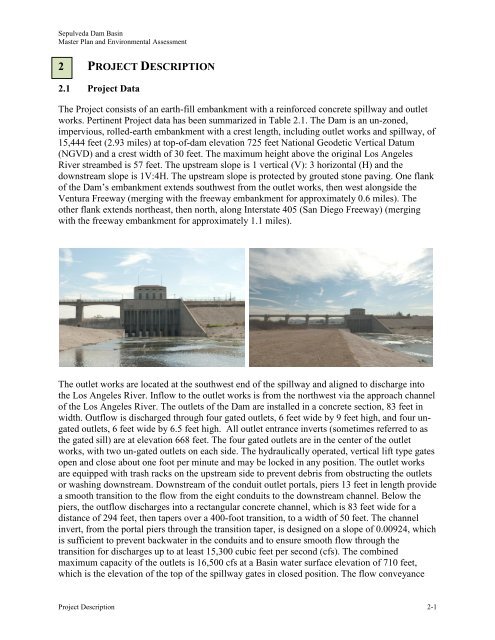
<strong>Sepulveda</strong> <strong>Dam</strong> <strong>Basin</strong><strong>Master</strong> <strong>Plan</strong> and Environmental Assessment2 PROJECT DESCRIPTION2.1 Project DataThe Project consists of an earth-fill embankment with a reinforced concrete spillway and outletworks. Pertinent Project data has been summarized in Table 2.1. The <strong>Dam</strong> is an un-zoned,impervious, rolled-earth embankment with a crest length, including outlet works and spillway, of15,444 feet (2.93 miles) at top-of-dam elevation 725 feet National Geodetic Vertical Datum(NGVD) and a crest width of 30 feet. The maximum height above the original <strong>Los</strong> <strong>Angeles</strong>River streambed is 57 feet. The upstream slope is 1 vertical (V): 3 horizontal (H) and thedownstream slope is 1V:4H. The upstream slope is protected by grouted stone paving. One flankof the <strong>Dam</strong>’s embankment extends southwest from the outlet works, then west alongside theVentura Freeway (merging with the freeway embankment for approximately 0.6 miles). Theother flank extends northeast, then north, along Interstate 405 (San Diego Freeway) (mergingwith the freeway embankment for approximately 1.1 miles).The outlet works are located at the southwest end of the spillway and aligned to discharge intothe <strong>Los</strong> <strong>Angeles</strong> River. Inflow to the outlet works is from the northwest via the approach channelof the <strong>Los</strong> <strong>Angeles</strong> River. The outlets of the <strong>Dam</strong> are installed in a concrete section, 83 feet inwidth. Outflow is discharged through four gated outlets, 6 feet wide by 9 feet high, and four ungatedoutlets, 6 feet wide by 6.5 feet high. All outlet entrance inverts (sometimes referred to asthe gated sill) are at elevation 668 feet. The four gated outlets are in the center of the outletworks, with two un-gated outlets on each side. The hydraulically operated, vertical lift type gatesopen and close about one foot per minute and may be locked in any position. The outlet worksare equipped with trash racks on the upstream side to prevent debris from obstructing the outletsor washing downstream. Downstream of the conduit outlet portals, piers 13 feet in length providea smooth transition to the flow from the eight conduits to the downstream channel. Below thepiers, the outflow discharges into a rectangular concrete channel, which is 83 feet wide for adistance of 294 feet, then tapers over a 400-foot transition, to a width of 50 feet. The channelinvert, from the portal piers through the transition taper, is designed on a slope of 0.00924, whichis sufficient to prevent backwater in the conduits and to ensure smooth flow through thetransition for discharges up to at least 15,300 cubic feet per second (cfs). The combinedmaximum capacity of the outlets is 16,500 cfs at a <strong>Basin</strong> water surface elevation of 710 feet,which is the elevation of the top of the spillway gates in closed position. The flow conveyanceProject Description 2-1