Sepulveda Dam Basin Master Plan - Los Angeles District - U.S. Army
Sepulveda Dam Basin Master Plan - Los Angeles District - U.S. Army
Sepulveda Dam Basin Master Plan - Los Angeles District - U.S. Army
- No tags were found...

You also want an ePaper? Increase the reach of your titles
YUMPU automatically turns print PDFs into web optimized ePapers that Google loves.
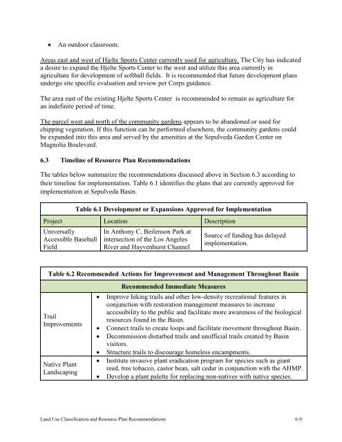
An outdoor classroom.Areas east and west of Hjelte Sports Center currently used for agriculture. The City has indicateda desire to expand the Hjelte Sports Center to the west and utilize this area currently inagriculture for development of softball fields. It is recommended that future development plansundergo site specific evaluation and review per Corps guidance.The area east of the existing Hjelte Sports Center is recommended to remain as agriculture foran indefinite period of time.The parcel west and north of the community gardens appears to be abandoned or used forchipping vegetation. If this function can be performed elsewhere, the community gardens couldbe expanded into this area and served by the amenities at the <strong>Sepulveda</strong> Garden Center onMagnolia Boulevard.6.3 Timeline of Resource <strong>Plan</strong> RecommendationsThe tables below summarize the recommendations discussed above in Section 6.3 according totheir timeline for implementation. Table 6.1 identifies the plans that are currently approved forimplementation at <strong>Sepulveda</strong> <strong>Basin</strong>.Table 6.1 Development or Expansions Approved for ImplementationProject Location DescriptionUniversallyAccessible BaseballFieldIn Anthony C. Beilenson Park atintersection of the <strong>Los</strong> <strong>Angeles</strong>River and Hayvenhurst ChannelSource of funding has delayedimplementation.Table 6.2 Recommended Actions for Improvement and Management Throughout <strong>Basin</strong>TrailImprovementsNative <strong>Plan</strong>tLandscapingRecommended Immediate MeasuresImprove hiking trails and other low-density recreational features inconjunction with restoration management measures to increaseaccessibility to the public and facilitate more awareness of the biologicalresources found in the <strong>Basin</strong>.Connect trails to create loops and facilitate movement throughout <strong>Basin</strong>.Decommission disturbed trails and unofficial trails created by <strong>Basin</strong>visitors.Structure trails to discourage homeless encampments.Institute invasive plant eradication program for species such as giantreed, tree tobacco, castor bean, salt cedar in conjunction with the AHMP.Develop a plant palette for replacing non-natives with native species.Land Use Classification and Resource <strong>Plan</strong> Recommendations 6-9