Sepulveda Dam Basin Master Plan - Los Angeles District - U.S. Army
Sepulveda Dam Basin Master Plan - Los Angeles District - U.S. Army
Sepulveda Dam Basin Master Plan - Los Angeles District - U.S. Army
- No tags were found...
You also want an ePaper? Increase the reach of your titles
YUMPU automatically turns print PDFs into web optimized ePapers that Google loves.
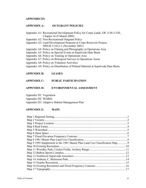
APPENDECESAPPENDIX A:OUTGRANT POLICIESAppendix A1: Recreational Development Policy for Corps Lands, ER 1130-2-550,Chapter 16 (9 March 2009)Appendix A2: Non-Recreational Outgrant PolicyAppendix A3: Land Development Proposal at Corps Reservoir Project,SPD-R 1110-2-1 (November 2001)Appendix A4: Policy on Filming and Photography in Operations AreaAppendix A5: Policy on Special Events at <strong>Sepulveda</strong> <strong>Dam</strong> <strong>Basin</strong>Appendix A6: Policy on Training in Operations AreaAppendix A7: Policy on Biological Surveys in Operations AreasAppendix A8: Policy on Volunteer ActivitiesAppendix A9: Policy on Distribution of Printed Material at <strong>Sepulveda</strong> <strong>Dam</strong> <strong>Basin</strong>APPENDIX B:APPENDIX C:APPENDIX D:LEASESPUBLIC PARTICIPATIONENVIRONMENTAL ASSESSMENTAppendix D1: VegetationAppendix D2: WildlifeAppendix D3: Adaptive Habitat Management <strong>Plan</strong>APPENDIX E:MAPSMap 1 Regional Setting ......................................................................................................1Map 2 Vicinity ....................................................................................................................2Map 3 Project Location ......................................................................................................3Map 4 Real Estate ...............................................................................................................4Map 5 Watershed ................................................................................................................5Map 6 Open Space .............................................................................................................6Map 7 Flood Elevation Frequency Contours .....................................................................7Map 8 1981 <strong>Master</strong> <strong>Plan</strong> Land Use Classification .............................................................8Map 9 1995 Supplement to the 1981 <strong>Master</strong> <strong>Plan</strong> Land Use Classification Map ..............9Map 10 Existing Recreation .............................................................................................10Map 11 Woodley Park, Cricket Fields, Archery Range ...................................................11Map 12 Balboa Sports Complex ......................................................................................12Map 13 Northwest <strong>Sepulveda</strong> Amenities .........................................................................13Map 14 Anthony C. Beilenson Park .................................................................................14Map 15 Nearby Recreation ...............................................................................................15Map 16 Existing Recreation and Flood Frequency Contours ..........................................16Map 17 Topography .........................................................................................................17Table of Contentsiii


