Status of Caribbean coral reefs after bleaching and hurricanes in 2005
Status of Caribbean coral reefs after bleaching and hurricanes in 2005
Status of Caribbean coral reefs after bleaching and hurricanes in 2005

You also want an ePaper? Increase the reach of your titles
YUMPU automatically turns print PDFs into web optimized ePapers that Google loves.
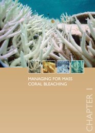
<strong>Status</strong> <strong>of</strong> Coral Reefs <strong>of</strong> the Lesser Antilles <strong>after</strong> the <strong>2005</strong> Coral Bleach<strong>in</strong>g EventBarbadosIn t r o d u c t i o nBarbados is the most easterly <strong>of</strong> the Lesser Antilles isl<strong>and</strong> cha<strong>in</strong>. The uplifted fossil <strong>coral</strong>isl<strong>and</strong> is surrounded by a 2-3 km wide shelf that supports a variety <strong>of</strong> <strong>coral</strong> <strong>reefs</strong>. Fr<strong>in</strong>g<strong>in</strong>g<strong>reefs</strong> dist<strong>in</strong>guish the west (leeward) coast <strong>and</strong> make up 8.4% <strong>of</strong> the mapped <strong>reefs</strong>; beyond thatthere is an almost cont<strong>in</strong>uous bank reef parallel to the north, west <strong>and</strong> south coasts 0.5 to 1.2km <strong>of</strong>fshore. The crest <strong>of</strong> this bank reef is 5-35 m deep <strong>in</strong> the north, west <strong>and</strong> south <strong>and</strong> isshallower along the more exposed southeast coast, where it becomes a bank barrier reef. Thisbank conta<strong>in</strong>s 87.1% <strong>of</strong> the mapped <strong>reefs</strong>. There are also a few patch <strong>reefs</strong> at 5-16 m depthbetween the shore <strong>and</strong> the bank reef, along the west to southeast coasts.Stat u s o f Co r a l Reefs Pr i o r to <strong>2005</strong>The <strong>in</strong>shore fr<strong>in</strong>g<strong>in</strong>g <strong>reefs</strong> have been affected by poor water quality caused by coastal construction,tourism <strong>in</strong>frastructure <strong>and</strong> <strong>in</strong>l<strong>and</strong> agriculture; by storms; <strong>and</strong> by over-exploitation <strong>of</strong> fish <strong>and</strong><strong>coral</strong>s. Average live <strong>coral</strong> cover is about 10% <strong>in</strong> the seaward spur <strong>and</strong> groove zone (range1-30%). The <strong>of</strong>fshore bank <strong>reefs</strong> are relatively undamaged with about 30% <strong>coral</strong> cover alongthe crest. These bank <strong>reefs</strong> are far enough <strong>of</strong>fshore to escape damage from poor water quality,<strong>and</strong> are also less accessible to fishers. The patch <strong>reefs</strong> are more variable; they are dom<strong>in</strong>atedby hard <strong>coral</strong>s <strong>and</strong> sponges on the west coast, <strong>and</strong> s<strong>of</strong>t <strong>coral</strong>s on the more exposed w<strong>in</strong>dwardcoasts, although hard <strong>coral</strong> cover averages 25%. There have been <strong>in</strong>frequent <strong>bleach<strong>in</strong>g</strong> events<strong>in</strong> south-eastern <strong>Caribbean</strong> isl<strong>and</strong>s; most have occurred with<strong>in</strong> the last decade but were usually<strong>of</strong> low to moderate <strong>in</strong>tensity.Effects o f t h e <strong>2005</strong> Bl e a c h i n g Ev e n tNOAA satellite sea surface temperature (SST) data for the eastern <strong>Caribbean</strong>, <strong>in</strong>clud<strong>in</strong>g Barbados,showed a <strong>coral</strong> <strong>bleach<strong>in</strong>g</strong> ‘HotSpot’ (SSTs <strong>in</strong> excess <strong>of</strong> 1 o C above the maximum expectedtemperatures) that developed to the northeast <strong>of</strong> Barbados <strong>in</strong> early June, <strong>and</strong> strengthened <strong>in</strong>June-July to cover Barbados <strong>and</strong> the Lesser Antilles by early August. The HotSpot strengtheneddur<strong>in</strong>g August <strong>and</strong> September <strong>and</strong> covered much <strong>of</strong> the <strong>Caribbean</strong> Sea by early October. Itf<strong>in</strong>ally disappeared <strong>in</strong> late October.Sea temperatures at 8 m depth on a shallow patch reef confirmed the satellite data, withdaily mean temperatures climb<strong>in</strong>g steadily from 28.6 o C <strong>in</strong> late June to more than 30 o C <strong>in</strong> lateAugust <strong>and</strong> early September. This was 1-2 o C above the ‘typical’ summer maximum. Dur<strong>in</strong>g thesecond <strong>and</strong> third weeks <strong>of</strong> September, strong currents brought cooler water onto the <strong>reefs</strong> <strong>and</strong>reduced temperatures by almost 1.5 o C, before they returned aga<strong>in</strong> to 30 o C for the last week <strong>of</strong>September. Sea temperatures decl<strong>in</strong>ed to 29.3 o C by the end <strong>of</strong> October <strong>and</strong> to 28.6 o C by theend <strong>of</strong> November. Benthic temperature loggers at 20 m depth on other sites showed similartemperature patterns to those reported by research divers <strong>and</strong> dive operators, with widespreadwarm waters extend<strong>in</strong>g to at least 30 m depth.97