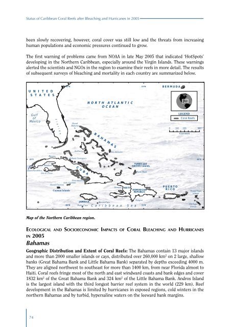
<strong>Status</strong> <strong>of</strong> <strong>Caribbean</strong> Coral Reefs <strong>after</strong> Bleach<strong>in</strong>g <strong>and</strong> Hurricanes <strong>in</strong> <strong>2005</strong>been slowly recover<strong>in</strong>g, however, <strong>coral</strong> cover was still low <strong>and</strong> the threats from <strong>in</strong>creas<strong>in</strong>ghuman populations <strong>and</strong> economic pressures cont<strong>in</strong>ued to grow.The first warn<strong>in</strong>g <strong>of</strong> problems came from NOAA <strong>in</strong> late May <strong>2005</strong> that <strong>in</strong>dicated ‘HotSpots’develop<strong>in</strong>g <strong>in</strong> the Northern <strong>Caribbean</strong>, especially around the Virg<strong>in</strong> Isl<strong>and</strong>s. These warn<strong>in</strong>gsalerted the scientists <strong>and</strong> NGOs <strong>in</strong> the region to exam<strong>in</strong>e their <strong>reefs</strong> <strong>in</strong> more detail. The results<strong>of</strong> subsequent surveys <strong>of</strong> <strong>bleach<strong>in</strong>g</strong> <strong>and</strong> mortality <strong>in</strong> each country are summarized below.U N I T E DS T A T E S80° W70° WBERMUD AN ORTH ATLANTICOCEA NGu lf<strong>of</strong>Mexi coGr<strong>and</strong>Baham aIsLEGENDCoral Reefs0 11 0 220 440F l o r i d aBAHAMA SKilometersAndros I sSan SalvadorHavanaSabana Camaguey23° N 23° NBatabanoTURKS <strong>and</strong>CA ICOS I sl<strong>and</strong>sGuanahacabibesIs la de P<strong>in</strong>o sCUBATurks BankGuacanayaboGr<strong>and</strong> C ay ma n Li ttl e CaymanCayman Isl<strong>and</strong>sGonaveHA IT IDOMINICA NREPU BLICPUERTOR ICOBritish Virg<strong>in</strong>Isl<strong>and</strong>s80° WJA MAIC APedro CaysJaraguaMorant Cays70° WC a r i b b e a n S e aUS Virg<strong>in</strong>Isl<strong>and</strong>sMap <strong>of</strong> the Northern <strong>Caribbean</strong> region.Ec o l o g i c a l a n d So c i o e c o n o m i c Im p a c t s o f Co r a l Bl e a c h i n g a n d Hu r r i ca n e s<strong>in</strong> <strong>2005</strong>BahamasGeographic Distribution <strong>and</strong> Extent <strong>of</strong> Coral Reefs: The Bahamas conta<strong>in</strong> 13 major isl<strong>and</strong>s<strong>and</strong> more than 2000 smaller isl<strong>and</strong>s or cays, distributed over 260,000 km 2 on 2 large, shallowbanks (Great Bahama Bank <strong>and</strong> Little Bahama Bank) separated by depths exceed<strong>in</strong>g 4000 m.They are aligned northwest to southeast for more than 1400 km, from near Florida almost toHaiti. Coral <strong>reefs</strong> fr<strong>in</strong>ge most <strong>of</strong> the north <strong>and</strong> east w<strong>in</strong>dward coasts <strong>and</strong> bank edges <strong>and</strong> cover1832 km 2 <strong>of</strong> the Great Bahama Bank <strong>and</strong> 324 km 2 <strong>of</strong> the Little Bahama Bank. Andros Isl<strong>and</strong>is the largest isl<strong>and</strong> with the third longest barrier reef system <strong>in</strong> the world (229 km). Reefdevelopment <strong>in</strong> the Bahamas is limited by <strong>hurricanes</strong> <strong>in</strong> exposed regions, cold w<strong>in</strong>ters <strong>in</strong> thenorthern Bahamas <strong>and</strong> by turbid, hypersal<strong>in</strong>e waters on the leeward bank marg<strong>in</strong>s.74
The Effects <strong>of</strong> Coral Bleach<strong>in</strong>g <strong>in</strong> the Northern <strong>Caribbean</strong> <strong>and</strong> Western Atlantic<strong>Status</strong> <strong>of</strong> <strong>coral</strong> <strong>reefs</strong> prior to <strong>2005</strong>: Prior to <strong>2005</strong>, live <strong>coral</strong> cover <strong>in</strong> the Bahamas was highlyvariable between sites, with cover rang<strong>in</strong>g between 1% at L<strong>in</strong>dsay Reef at 4 m depth to 47%at Strip Reef at 10 m.Impacts <strong>of</strong> Coral Bleach<strong>in</strong>g <strong>in</strong> <strong>2005</strong>: Reef Check conducted one survey at Turtle Rocks <strong>in</strong>August <strong>2005</strong> dur<strong>in</strong>g the <strong>coral</strong> <strong>bleach<strong>in</strong>g</strong> episode. This survey determ<strong>in</strong>ed that live <strong>coral</strong> coverwas 14%; 17% <strong>of</strong> <strong>coral</strong> colonies were affected by <strong>bleach<strong>in</strong>g</strong>; <strong>and</strong> bleached colonies exhibited<strong>bleach<strong>in</strong>g</strong> over 25-50% <strong>of</strong> their surface. No recently killed <strong>coral</strong> was recorded dur<strong>in</strong>g thesurvey <strong>and</strong> a subsequent survey conducted <strong>in</strong> August 2006 recorded live hard <strong>coral</strong> cover<strong>of</strong> 18%, <strong>in</strong>dicat<strong>in</strong>g that the <strong>2005</strong> <strong>bleach<strong>in</strong>g</strong> event caused little or no <strong>coral</strong> mortality <strong>in</strong> theBahamas.BermudaGeographic Distribution <strong>and</strong> Extent <strong>of</strong> Coral Reefs: Bermuda is an isolated isl<strong>and</strong> cha<strong>in</strong> 920km <strong>of</strong>f the coast <strong>of</strong> North Carol<strong>in</strong>a on the Bermuda Platform. Together with the Challenger <strong>and</strong>Argus Banks, they occupy about 900 km 2 . The fr<strong>in</strong>g<strong>in</strong>g, bank-barrier <strong>and</strong> lagoonal patch <strong>reefs</strong>form the most northerly <strong>coral</strong> reef system <strong>in</strong> the Atlantic <strong>and</strong> are supported by warm watereddies from the nearby Gulf Stream. Coral diversity is, however, limited by cool w<strong>in</strong>ters.<strong>Status</strong> <strong>of</strong> <strong>coral</strong> <strong>reefs</strong> prior to <strong>2005</strong>: There has been little change <strong>in</strong> these <strong>coral</strong> <strong>reefs</strong>, which arethe most northerly <strong>reefs</strong> <strong>of</strong> the region (Latitude 32°20’N), dur<strong>in</strong>g the 10 years to <strong>2005</strong>. Coralcover rema<strong>in</strong>ed at 20% around the rim, 10-15% on lagoon patch <strong>reefs</strong>, <strong>and</strong> 45-50% on terrace<strong>reefs</strong>. There are healthy herbivorous fish populations, <strong>and</strong> the <strong>reefs</strong> escaped serious impactscaused by <strong>coral</strong> <strong>bleach<strong>in</strong>g</strong> that damaged <strong>reefs</strong> to the south <strong>in</strong> <strong>2005</strong>. A comparison with the firstsurveys 25 years ago illustrates the stability: hard <strong>coral</strong> cover on the terraces - 52.4% <strong>in</strong> 1981vs 54.0% <strong>in</strong> <strong>2005</strong>; <strong>and</strong> 22.5% <strong>in</strong> 1981 on outer rim <strong>coral</strong>-algal <strong>reefs</strong> vs 24% <strong>in</strong> <strong>2005</strong>. Much <strong>of</strong>the stability on Bermudan <strong>reefs</strong> could be the result <strong>of</strong> a predom<strong>in</strong>ance <strong>of</strong> slow grow<strong>in</strong>g massivegrowth forms (Diploria, Montastraea <strong>and</strong> Porites species) <strong>and</strong> few branch<strong>in</strong>g <strong>and</strong> <strong>bleach<strong>in</strong>g</strong>sensitive <strong>coral</strong>s like Acropora.Impacts <strong>of</strong> Coral Bleach<strong>in</strong>g <strong>in</strong> <strong>2005</strong>: Some <strong>coral</strong> <strong>bleach<strong>in</strong>g</strong> was observed on Bermudan <strong>reefs</strong><strong>in</strong> 1988, 1991, 1992, 1995, 1998 <strong>and</strong> 2003, however, only the 1988 <strong>and</strong> 2003 events wererecorded <strong>in</strong> detail. In <strong>2005</strong>, seawater temperatures peaked at 30.3°C <strong>in</strong> mid to late August atmost locations, except at 10-15 m depth on the terrace reef sites, which peaked at 28.7°C <strong>in</strong>early September. All sites cooled with the passage <strong>of</strong> tropical storm Philippe. Thus, seawatertemperatures dur<strong>in</strong>g <strong>2005</strong> were not unusual compared with previous summers <strong>and</strong> nowidespread <strong>bleach<strong>in</strong>g</strong> or disease <strong>of</strong> <strong>coral</strong>s was observed. Hard <strong>coral</strong> cover was 22.7% <strong>in</strong> <strong>2005</strong>;the same as 2004 <strong>and</strong> a slight <strong>in</strong>crease on the 14 year mean (20.8%). Black-b<strong>and</strong> disease <strong>and</strong>white plague on Diploria, Montastraea <strong>and</strong> Porites astreoides are the most common diseases<strong>in</strong> Bermuda, <strong>and</strong> occur mostly on the outer rim <strong>and</strong> lagoonal patch <strong>reefs</strong>. Yellow blotch diseaseis also relatively common <strong>in</strong> Montastraea franksii.Impacts <strong>of</strong> Hurricanes <strong>in</strong> <strong>2005</strong>: In <strong>2005</strong>, there were 3 tropical storms (‘Frankl<strong>in</strong>’, ‘Harvey’ <strong>and</strong>‘Philippe’) <strong>and</strong> 2 <strong>hurricanes</strong> (‘Nate’ <strong>and</strong> ‘Wilma’) near Bermuda. However, peak w<strong>in</strong>d speedsdid not exceed 90 km/h (i.e. generally less than regular w<strong>in</strong>ter storms). The major effects <strong>of</strong>these storms were to temporarily lower seawater temperatures by 1-2°C, with no significantdamage to the <strong>coral</strong> <strong>reefs</strong>.75