The Rimba Raya Biodiversity Reserve REDD Project
The Rimba Raya Biodiversity Reserve REDD Project
The Rimba Raya Biodiversity Reserve REDD Project

Create successful ePaper yourself
Turn your PDF publications into a flip-book with our unique Google optimized e-Paper software.
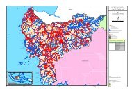
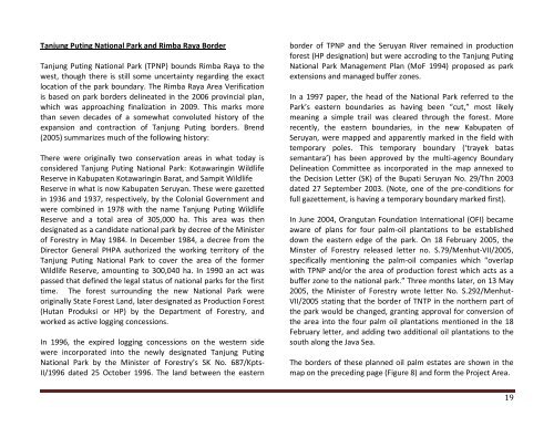
Tanjung Puting National Park and <strong>Rimba</strong> <strong>Raya</strong> BorderTanjung Puting National Park (TPNP) bounds <strong>Rimba</strong> <strong>Raya</strong> to thewest, though there is still some uncertainty regarding the exactlocation of the park boundary. <strong>The</strong> <strong>Rimba</strong> <strong>Raya</strong> Area Verificationis based on park borders delineated in the 2006 provincial plan,which was approaching finalization in 2009. This marks morethan seven decades of a somewhat convoluted history of theexpansion and contraction of Tanjung Puting borders. Brend(2005) summarizes much of the following history:<strong>The</strong>re were originally two conservation areas in what today isconsidered Tanjung Puting National Park: Kotawaringin Wildlife<strong>Reserve</strong> in Kabupaten Kotawaringin Barat, and Sampit Wildlife<strong>Reserve</strong> in what is now Kabupaten Seruyan. <strong>The</strong>se were gazettedin 1936 and 1937, respectively, by the Colonial Government andwere combined in 1978 with the name Tanjung Puting Wildlife<strong>Reserve</strong> and a total area of 305,000 ha. This area was thendesignated as a candidate national park by decree of the Ministerof Forestry in May 1984. In December 1984, a decree from theDirector General PHPA authorized the working territory of theTanjung Puting National Park to cover the area of the formerWildlife <strong>Reserve</strong>, amounting to 300,040 ha. In 1990 an act waspassed that defined the legal status of national parks for the firsttime. <strong>The</strong> forest surrounding the new National Park wereoriginally State Forest Land, later designated as Production Forest(Hutan Produksi or HP) by the Department of Forestry, andworked as active logging concessions.In 1996, the expired logging concessions on the western sidewere incorporated into the newly designated Tanjung PutingNational Park by the Minister of Forestry’s SK No. 687/Kpts-‐II/1996 dated 25 October 1996. <strong>The</strong> land between the easternborder of TPNP and the Seruyan River remained in productionforest (HP designation) but were accroding to the Tanjung PutingNational Park Management Plan (MoF 1994) proposed as parkextensions and managed buffer zones.In a 1997 paper, the head of the National Park referred to thePark’s eastern boundaries as having been “cut,” most likelymeaning a simple trail was cleared through the forest. Morerecently, the eastern boundaries, in the new Kabupaten ofSeruyan, were mapped and apparently marked in the field withtemporary poles. This temporary boundary (‘trayek batassemantara’) has been approved by the multi-‐agency BoundaryDelineation Committee as incorporated in the map annexed tothe Decision Letter (SK) of the Bupati Seruyan No. 29/Thn 2003dated 27 September 2003. (Note, one of the pre-‐conditions forfull gazettement, is having a temporary boundary marked first).In June 2004, Orangutan Foundation International (OFI) becameaware of plans for four palm-‐oil plantations to be establisheddown the eastern edge of the park. On 18 February 2005, theMinster of Forestry released letter no. S.79/Menhut-‐VII/2005,specifically mentioning the palm-‐oil companies which “overlapwith TPNP and/or the area of production forest which acts as abuffer zone to the national park.” Three months later, on 13 May2005, the Minister of Forestry wrote letter No. S.292/Menhut-‐VII/2005 stating that the border of TNTP in the northern part ofthe park would be changed, granting approval for conversion ofthe area into the four palm oil plantations mentioned in the 18February letter, and adding two additional oil plantations to thesouth along the Java Sea.<strong>The</strong> borders of these planned oil palm estates are shown in themap on the preceding page (Figure 8) and form the <strong>Project</strong> Area.19