(SAR) to Support Agricultural Monitoring 2 - Group on Earth ...
(SAR) to Support Agricultural Monitoring 2 - Group on Earth ...
(SAR) to Support Agricultural Monitoring 2 - Group on Earth ...

Create successful ePaper yourself
Turn your PDF publications into a flip-book with our unique Google optimized e-Paper software.
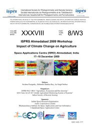
Internati<strong>on</strong>al GEO Workshop <strong>on</strong> <str<strong>on</strong>g>SAR</str<strong>on</strong>g> <str<strong>on</strong>g>to</str<strong>on</strong>g> <str<strong>on</strong>g>Support</str<strong>on</strong>g> <str<strong>on</strong>g>Agricultural</str<strong>on</strong>g> M<strong>on</strong>i<str<strong>on</strong>g>to</str<strong>on</strong>g>ring<br />
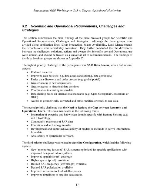
3.2 Scientific and Operati<strong>on</strong>al Requirements, Challenges and<br />
Strategies<br />
This secti<strong>on</strong> summarizes the main findings of the three breakout groups for Scientific and<br />
Operati<strong>on</strong>al Requirements, Challenges and Strategies. Although the three groups were<br />
divided al<strong>on</strong>g applicati<strong>on</strong> lines (Crop Producti<strong>on</strong>, Water Availability, Land Management),<br />
their c<strong>on</strong>clusi<strong>on</strong>s were remarkably c<strong>on</strong>sistent. They further c<strong>on</strong>cluded that the differences<br />
between the challenges, soluti<strong>on</strong>s, acti<strong>on</strong>s and owners for Scientific use and Operati<strong>on</strong>al use<br />
were similar, and should be treated as a universal set of recommendati<strong>on</strong>s. The findings of<br />
the three breakout groups are shown in Appendix C.<br />
The highest priority challenge of the participants was <str<strong>on</strong>g>SAR</str<strong>on</strong>g> Data Access, which had several<br />
aspects:<br />
• Reduced data cost<br />
• Improved data policies (e.g. data access and sharing, data c<strong>on</strong>tinuity)<br />
• Easier data discovery and order process (e.g. global portal)<br />
• Greater access <str<strong>on</strong>g>to</str<strong>on</strong>g> new acquisiti<strong>on</strong>s<br />
• Greater access <str<strong>on</strong>g>to</str<strong>on</strong>g> his<str<strong>on</strong>g>to</str<strong>on</strong>g>rical data archives<br />
• Coordinati<strong>on</strong> <str<strong>on</strong>g>to</str<strong>on</strong>g> existing in-situ data<br />
• Data sharing based <strong>on</strong> internati<strong>on</strong>al standards (e.g. Open Geospatial C<strong>on</strong>sortium or<br />
OGC)<br />
• Access <str<strong>on</strong>g>to</str<strong>on</strong>g> geometrically corrected and ortho-rectified or ready-<str<strong>on</strong>g>to</str<strong>on</strong>g>-use data.<br />
The sec<strong>on</strong>d priority challenge was the Need <str<strong>on</strong>g>to</str<strong>on</strong>g> Reduce the Gap between Research and<br />
Operati<strong>on</strong>al Users. This was manifested in the following forms:<br />
• Integrati<strong>on</strong> of expertise and knowledge domain specific with Remote Sensing (e.g.<br />
soil + hydrology)<br />
• Community awareness of <str<strong>on</strong>g>SAR</str<strong>on</strong>g> data<br />
• Educati<strong>on</strong> and technology transfer<br />
• Development and improved availability of models or methods <str<strong>on</strong>g>to</str<strong>on</strong>g> derive informati<strong>on</strong><br />
from data<br />
• Availability of operati<strong>on</strong>al software.<br />
The third priority challenge was related <str<strong>on</strong>g>to</str<strong>on</strong>g> Satellite C<strong>on</strong>figurati<strong>on</strong>, which had the following<br />
aspects:<br />
• New ‘m<strong>on</strong>i<str<strong>on</strong>g>to</str<strong>on</strong>g>ring focussed’ <str<strong>on</strong>g>SAR</str<strong>on</strong>g> systems optimized for specific applicati<strong>on</strong>s with<br />
improved design of future systems<br />
• Improved spatial (swath) coverage<br />
• Higher spatial (pixel) resoluti<strong>on</strong><br />
• Desired <str<strong>on</strong>g>SAR</str<strong>on</strong>g> frequency (wavelength) available<br />
• Desired <str<strong>on</strong>g>SAR</str<strong>on</strong>g> polarizati<strong>on</strong> available<br />
• Improved revisit/re-look of satellite passes<br />
• Improved timeliness of satellite data access.<br />
17