(SAR) to Support Agricultural Monitoring 2 - Group on Earth ...
(SAR) to Support Agricultural Monitoring 2 - Group on Earth ...
(SAR) to Support Agricultural Monitoring 2 - Group on Earth ...

Create successful ePaper yourself
Turn your PDF publications into a flip-book with our unique Google optimized e-Paper software.
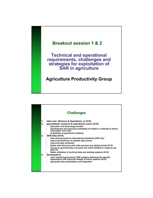
Breakout sessi<strong>on</strong> 1 & 2<br />
Technical and operati<strong>on</strong>al<br />
requirements, challenges and<br />
strategies for exploitati<strong>on</strong> of<br />
<str<strong>on</strong>g>SAR</str<strong>on</strong>g> in agriculture<br />
Agriculture Productivity <str<strong>on</strong>g>Group</str<strong>on</strong>g><br />
Challenges<br />
1. data cost (Science & Operati<strong>on</strong>s, or S+O)<br />
2. gap between research & operati<strong>on</strong>al users (S+O)<br />
– Educati<strong>on</strong> and technology transfer<br />
– Development and improved availability of models or methods <str<strong>on</strong>g>to</str<strong>on</strong>g> derive<br />
informati<strong>on</strong> from data<br />
– Availability of operati<strong>on</strong>al software<br />
3. <str<strong>on</strong>g>SAR</str<strong>on</strong>g> Data (S+O)<br />
– data sharing based <strong>on</strong> internati<strong>on</strong>al standards (OGC etc)<br />
– improved timeliness of satellite data access<br />
– Improved data c<strong>on</strong>tinuity<br />
– Easier data discovery and order process (e.g. global portal) (S+O)<br />
– Access <str<strong>on</strong>g>to</str<strong>on</strong>g> geometrically corrected and ortho-rectified or ready-<str<strong>on</strong>g>to</str<strong>on</strong>g>-use<br />
data (O)<br />
– Better utilizati<strong>on</strong> of archived data and existing systems (S+O)<br />
4. Development<br />
– new ‘m<strong>on</strong>i<str<strong>on</strong>g>to</str<strong>on</strong>g>ring focussed’<str<strong>on</strong>g>SAR</str<strong>on</strong>g> systems optimized for specific<br />
applicati<strong>on</strong>s with improved design of future systems (S+O)<br />
– geospatial data assimilati<strong>on</strong> and integrati<strong>on</strong>