(SAR) to Support Agricultural Monitoring 2 - Group on Earth ...
(SAR) to Support Agricultural Monitoring 2 - Group on Earth ...
(SAR) to Support Agricultural Monitoring 2 - Group on Earth ...

You also want an ePaper? Increase the reach of your titles
YUMPU automatically turns print PDFs into web optimized ePapers that Google loves.
M<strong>on</strong>i<str<strong>on</strong>g>to</str<strong>on</strong>g>ring<br />
Applicati<strong>on</strong><br />
Internati<strong>on</strong>al GEO Workshop <strong>on</strong> <str<strong>on</strong>g>SAR</str<strong>on</strong>g> <str<strong>on</strong>g>to</str<strong>on</strong>g> <str<strong>on</strong>g>Support</str<strong>on</strong>g> <str<strong>on</strong>g>Agricultural</str<strong>on</strong>g> M<strong>on</strong>i<str<strong>on</strong>g>to</str<strong>on</strong>g>ring<br />
Currently Use<br />
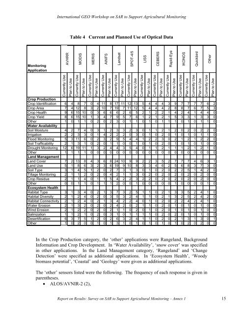
AVHRR<br />
Table 4 Current and Planned Use of Optical Data<br />
Plan <str<strong>on</strong>g>to</str<strong>on</strong>g> Use<br />
Currently Use<br />
MODIS<br />
Plan <str<strong>on</strong>g>to</str<strong>on</strong>g> Use<br />
Currently Use<br />
MERIS<br />
Plan <str<strong>on</strong>g>to</str<strong>on</strong>g> Use<br />
Currently Use<br />
AWiFS<br />
Plan <str<strong>on</strong>g>to</str<strong>on</strong>g> Use<br />
Currently Use<br />
Landsat<br />
Plan <str<strong>on</strong>g>to</str<strong>on</strong>g> Use<br />
In the Crop Producti<strong>on</strong> category, the ‘other’ applicati<strong>on</strong>s were Rangeland, Background<br />
Informati<strong>on</strong> and Crop Development. In ‘Water Availability’, ‘snow cover’ was specified<br />
in other applicati<strong>on</strong>s. In the Land Management category, ‘Rangeland’ and ‘Change<br />
Detecti<strong>on</strong>’ were specified as additi<strong>on</strong>al applicati<strong>on</strong>s. In ‘Ecosystem Health’, ‘Woody<br />
biomass potential’, ‘Coastal’ and ‘Geology’ were given as additi<strong>on</strong>al applicati<strong>on</strong>s.<br />
The ‘other’ sensors listed were the following. The frequency of each resp<strong>on</strong>se is given in<br />
parentheses.<br />
• ALOS/AVNIR-2 (2),<br />
Currently Use<br />
Plan <str<strong>on</strong>g>to</str<strong>on</strong>g> Use<br />
Currently Use<br />
Plan <str<strong>on</strong>g>to</str<strong>on</strong>g> Use<br />
Currently Use<br />
Crop Producti<strong>on</strong><br />
Crop Identificati<strong>on</strong> 6 4 8 7 0 4 11 8 17 11 12 13 5 4 4 4 3 9 7 7 7 7 6 2<br />
Crop Area 7 4 12 8 3 2 10 7 19 7 11 12 5 4 4 4 2 8 8 7 6 7 5 3<br />
Crop Health 9 6 15 10 0 3 6 6 6 2 6 5 2 1 2 2 1 4 2 4 1 4 4 0<br />
Crop Yield 8 6 15 10 1 3 4 7 9 5 7 6 1 2 1 2 1 5 3 3 1 3 3 0<br />
Other 1 0 1 1 0 2 0 2 3 0 1 1 0 1 0 1 1 1 0 1 0 1 1 0<br />
Water Availability<br />
Soil Moisture 4 2 7 4 0 3 1 2 3 3 2 3 0 1 1 2 1 2 0 2 0 2 2 0<br />
Irrigati<strong>on</strong> 2 2 3 3 0 1 4 2 2 2 0 3 0 1 0 2 0 1 0 1 0 1 1 0<br />
Flood M<strong>on</strong>i<str<strong>on</strong>g>to</str<strong>on</strong>g>ring 5 3 11 6 0 2 3 2 9 5 4 4 1 2 2 3 0 2 1 2 1 2 2 0<br />
Soil Trafficability 2 1 3 1 0 2 0 1 1 0 0 1 0 1 0 2 0 1 0 1 0 1 0 0<br />
Drought M<strong>on</strong>i<str<strong>on</strong>g>to</str<strong>on</strong>g>ring 12 6 19 11 1 3 2 4 4 3 5 4 0 1 1 2 1 1 1 2 1 2 1 0<br />
Other 1 1 1 1 0 0 0 0 0 0 0 0 0 0 0 0 0 0 0 0 0 0 0 0<br />
Land Management<br />
Land Cover 7 2 13 8 4 3 6 8 24 10 9 9 2 2 3 5 2 7 7 7 4 6 3 1<br />
Land Use 5 1 8 6 3 2 3 6 19 9 10 8 3 3 4 6 2 5 6 8 3 7 3 0<br />
Soil Type 3 1 4 5 1 2 0 2 7 3 1 3 0 1 0 2 0 2 2 5 1 4 2 0<br />
Tillage M<strong>on</strong>i<str<strong>on</strong>g>to</str<strong>on</strong>g>ring 2 1 1 2 0 2 0 4 2 1 1 3 0 2 0 2 0 2 0 2 0 2 0 0<br />
Crop Residue 2 1 1 4 0 1 1 5 4 2 2 3 2 2 0 2 0 2 0 2 0 2 0 0<br />
Other 0 0 1 1 0 1 1 1 2 0 0 1 0 0 0 0 0 1 0 0 0 0 1 0<br />
Ecosystem Health<br />
Habitat Type 3 1 3 4 0 2 1 3 7 3 2 5 1 1 0 2 1 3 3 5 2 4 1 0<br />
Habitat Diversity 2 1 2 4 0 2 0 3 5 3 2 4 1 1 0 2 1 3 2 5 2 4 2 0<br />
Habitat C<strong>on</strong>nectivity 2 1 2 4 0 2 1 3 4 2 2 4 0 1 0 2 0 2 2 4 2 4 1 0<br />
Water Erosi<strong>on</strong> 2 1 3 2 0 2 0 2 4 2 0 2 1 1 0 2 0 1 0 1 0 1 0 0<br />
Wind Erosi<strong>on</strong> 2 1 2 2 0 2 0 2 1 1 0 2 0 1 0 2 0 1 0 1 0 1 0 0<br />
Salinizati<strong>on</strong> 1 1 2 1 0 2 0 3 1 0 1 1 1 1 0 2 0 2 0 1 0 1 0 0<br />
Desertificati<strong>on</strong> 6 3 7 5 1 2 0 2 6 3 2 4 1 1 0 2 0 2 1 3 1 3 0 1<br />
Other 1 0 2 0 0 1 0 1 3 1 0 1 0 1 0 1 0 1 0 2 0 2 0 0<br />
SPOT-4/5<br />
Report <strong>on</strong> Results: Survey <strong>on</strong> <str<strong>on</strong>g>SAR</str<strong>on</strong>g> <str<strong>on</strong>g>to</str<strong>on</strong>g> <str<strong>on</strong>g>Support</str<strong>on</strong>g> <str<strong>on</strong>g>Agricultural</str<strong>on</strong>g> M<strong>on</strong>i<str<strong>on</strong>g>to</str<strong>on</strong>g>ring – Annex 1 15<br />
LISS<br />
CEBERS<br />
Plan <str<strong>on</strong>g>to</str<strong>on</strong>g> Use<br />
Currently Use<br />
Rapid-Eye<br />
Plan <str<strong>on</strong>g>to</str<strong>on</strong>g> Use<br />
Currently Use<br />
IKONOS<br />
Plan <str<strong>on</strong>g>to</str<strong>on</strong>g> Use<br />
Currently Use<br />
Quickbird<br />
Plan <str<strong>on</strong>g>to</str<strong>on</strong>g> Use<br />
Other<br />
Currently Use<br />
Plan <str<strong>on</strong>g>to</str<strong>on</strong>g> Use