(SAR) to Support Agricultural Monitoring 2 - Group on Earth ...
(SAR) to Support Agricultural Monitoring 2 - Group on Earth ...
(SAR) to Support Agricultural Monitoring 2 - Group on Earth ...

You also want an ePaper? Increase the reach of your titles
YUMPU automatically turns print PDFs into web optimized ePapers that Google loves.
M<strong>on</strong>i<str<strong>on</strong>g>to</str<strong>on</strong>g>ring<br />
Applicati<strong>on</strong><br />
Land<br />
Management<br />
Land Cover<br />
Land Use<br />
Soil Type<br />
Tillage<br />
M<strong>on</strong>i<str<strong>on</strong>g>to</str<strong>on</strong>g>ring<br />
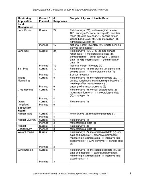
Internati<strong>on</strong>al GEO Workshop <strong>on</strong> <str<strong>on</strong>g>SAR</str<strong>on</strong>g> <str<strong>on</strong>g>to</str<strong>on</strong>g> <str<strong>on</strong>g>Support</str<strong>on</strong>g> <str<strong>on</strong>g>Agricultural</str<strong>on</strong>g> M<strong>on</strong>i<str<strong>on</strong>g>to</str<strong>on</strong>g>ring<br />
Current /<br />
Planned<br />
#<br />
Resp<strong>on</strong>ses<br />
Sample of Types of In-situ Data<br />
Current 27 Field surveys (21), meteorological data (4),<br />
GPS surveys (2), aerial surveys (2), ancillary<br />
maps (1), crop calendar (1), census data (1),<br />
Corine Land Cover (1), GIS informati<strong>on</strong> (1),<br />
administrative data (1)<br />
Planned 12 Nati<strong>on</strong>al Forest Inven<str<strong>on</strong>g>to</str<strong>on</strong>g>ry (1), remote sensing<br />
derived land maps (1)<br />
Current 24 Field surveys (18), GPS (2), Soil surface<br />
roughness (1), meteorological data (1),<br />
demographic (1), aerial surveys (1), census<br />
data (1), GIS informati<strong>on</strong> (1), administrative<br />
data (1)<br />
Planned 12 Nati<strong>on</strong>al Forest Inven<str<strong>on</strong>g>to</str<strong>on</strong>g>ry (1)<br />
Current 10 Field surveys (4), soil profiles (2), agricultural<br />
census data (1), meteorological data (1)<br />
Planned 7 Sensor network (1)<br />
Current 8 Field surveys (5), meteorological data (3),<br />
surface roughness instruments (pin board) (1),<br />
needle profiler measurements (1)<br />
Planned 6 Laser profiler measurements (2)<br />
Crop Residue Current 8 Field surveys (5), vertical pho<str<strong>on</strong>g>to</str<strong>on</strong>g>graphs (2),<br />
inputs from farmers (1), meteorological data<br />
(1), crop type (1)<br />
Planned 4<br />
Other:<br />
Current 1 Field surveys (1)<br />
rangeland<br />
Ecosystem<br />
Health<br />
Planned 0<br />
Habitat Type Current 7 field surveys (6), meteorological data (1)<br />
Planned 4<br />
Habitat Diversity Current 5 Field surveys (4)<br />
Planned 3 Meteorological data (1)<br />
Habitat<br />
Current 4 Field surveys (3)<br />
C<strong>on</strong>nectivity Planned 3 Meteorological data (1)<br />
Water Erosi<strong>on</strong> Current 7 Field surveys (2), meteorological data (2), soil<br />
data and models (1), extensive permanent<br />
m<strong>on</strong>i<str<strong>on</strong>g>to</str<strong>on</strong>g>ring instrumentati<strong>on</strong> (1), intensive field<br />
experiments (1), GPS surveys (1), census data<br />
(1)<br />
Planned 3<br />
Wind Erosi<strong>on</strong> Current 4 Field surveys (1), meteorological data (1), soil<br />
data and models (1), extensive permanent<br />
m<strong>on</strong>i<str<strong>on</strong>g>to</str<strong>on</strong>g>ring instrumentati<strong>on</strong> (1), intensive field<br />
experiments (1)<br />
Planned 3<br />
Report <strong>on</strong> Results: Survey <strong>on</strong> <str<strong>on</strong>g>SAR</str<strong>on</strong>g> <str<strong>on</strong>g>to</str<strong>on</strong>g> <str<strong>on</strong>g>Support</str<strong>on</strong>g> <str<strong>on</strong>g>Agricultural</str<strong>on</strong>g> M<strong>on</strong>i<str<strong>on</strong>g>to</str<strong>on</strong>g>ring – Annex 1 18