(SAR) to Support Agricultural Monitoring 2 - Group on Earth ...
(SAR) to Support Agricultural Monitoring 2 - Group on Earth ...
(SAR) to Support Agricultural Monitoring 2 - Group on Earth ...

You also want an ePaper? Increase the reach of your titles
YUMPU automatically turns print PDFs into web optimized ePapers that Google loves.
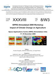
Internati<strong>on</strong>al GEO Workshop <strong>on</strong> <str<strong>on</strong>g>SAR</str<strong>on</strong>g> <str<strong>on</strong>g>to</str<strong>on</strong>g> <str<strong>on</strong>g>Support</str<strong>on</strong>g> <str<strong>on</strong>g>Agricultural</str<strong>on</strong>g> M<strong>on</strong>i<str<strong>on</strong>g>to</str<strong>on</strong>g>ring<br />
• ASTER (3),<br />
• GeoEye-1 (2),<br />
• Eros B (1),<br />
• Airborne systems (1),<br />
• Feng Yun 1D (CHRPT) (1),<br />
• hyperspectral data (1),<br />
• LiDAR (1),<br />
• GreenSeeker (1) and<br />
• Kompsat (1).<br />
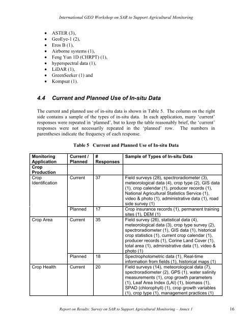
4.4 Current and Planned Use of In-situ Data<br />
The current and planned use of in-situ data is shown in Table 5. The column <strong>on</strong> the right<br />
side c<strong>on</strong>tains a sample of the types of in-situ data. In each applicati<strong>on</strong>, many ‘current’<br />
resp<strong>on</strong>ses were repeated in ‘planned’, but <str<strong>on</strong>g>to</str<strong>on</strong>g> keep the table reas<strong>on</strong>ably brief, the ‘current’<br />
resp<strong>on</strong>ses were not necessarily repeated in the ‘planned’ row. The numbers in<br />
parentheses indicate the frequency of each resp<strong>on</strong>se.<br />
M<strong>on</strong>i<str<strong>on</strong>g>to</str<strong>on</strong>g>ring<br />
Applicati<strong>on</strong><br />
Crop<br />
Producti<strong>on</strong><br />
Crop<br />
Identificati<strong>on</strong><br />
Crop Area<br />
Table 5 Current and Planned Use of In-situ Data<br />
Current /<br />
Planned<br />
#<br />
Resp<strong>on</strong>ses<br />
Sample of Types of In-situ Data<br />
Current 37 Field surveys (28), spectroradiometer (3),<br />
meteorological data (4), crop type (2), GIS data<br />
(1), crop calendar (1), producer records (1),<br />
Nati<strong>on</strong>al <str<strong>on</strong>g>Agricultural</str<strong>on</strong>g> Statistics Service (1),<br />
video & pho<str<strong>on</strong>g>to</str<strong>on</strong>g> (1), administrative data (1), road<br />
side survey (1)<br />
Planned 17 Crop insurance records (1), permanent training<br />
sites (1), DEM (1)<br />
Current 35 Field survey (26), statistical data (4),<br />
meteorological data (3), crop type survey (2),<br />
spectroradiometer (1), GIS data (1), his<str<strong>on</strong>g>to</str<strong>on</strong>g>rical<br />
crop statistics (1), current crop calendar (1),<br />
producer records (1), Corine Land Cover (1),<br />
<str<strong>on</strong>g>to</str<strong>on</strong>g>tal area (1), administrative data (1), video &<br />
pho<str<strong>on</strong>g>to</str<strong>on</strong>g> (1)<br />
Planned 18 Spectropho<str<strong>on</strong>g>to</str<strong>on</strong>g>metric data (1), Real-time<br />
informati<strong>on</strong> from fields (1), his<str<strong>on</strong>g>to</str<strong>on</strong>g>rical maps (1)<br />
Crop Health Current 20 Field surveys (14), meteorological data (7),<br />
spectroradiometer (2), GPS (1), water salinity<br />
measurements (1), crop growth parameters<br />
(1), Leaf Area Index (LAI) (1), biomass (1),<br />
SPAD (chlorophyll) (1), crop growth variables<br />
(1), crop type (1), management practices (1)<br />
Report <strong>on</strong> Results: Survey <strong>on</strong> <str<strong>on</strong>g>SAR</str<strong>on</strong>g> <str<strong>on</strong>g>to</str<strong>on</strong>g> <str<strong>on</strong>g>Support</str<strong>on</strong>g> <str<strong>on</strong>g>Agricultural</str<strong>on</strong>g> M<strong>on</strong>i<str<strong>on</strong>g>to</str<strong>on</strong>g>ring – Annex 1 16