(SAR) to Support Agricultural Monitoring 2 - Group on Earth ...
(SAR) to Support Agricultural Monitoring 2 - Group on Earth ...
(SAR) to Support Agricultural Monitoring 2 - Group on Earth ...

You also want an ePaper? Increase the reach of your titles
YUMPU automatically turns print PDFs into web optimized ePapers that Google loves.
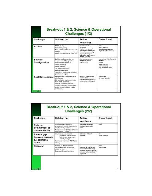
Break-out 1 & 2, Science & Operati<strong>on</strong>al<br />
Challenges (1/2)<br />
Challenge Soluti<strong>on</strong> (s) Acti<strong>on</strong>/<br />
Next Steps<br />
Access<br />
Satellite<br />
C<strong>on</strong>figurati<strong>on</strong><br />
Tool Development<br />
<str<strong>on</strong>g>SAR</str<strong>on</strong>g> Data Buy<br />
Data Sharing policy<br />
More satellites and coordinated data<br />
capture<br />
Global database with the in-situ data<br />
Defining and Documenting the<br />
requirements of the agriculture<br />
community with respect <str<strong>on</strong>g>to</str<strong>on</strong>g>:<br />
Spatial resoluti<strong>on</strong><br />
Spatial coverage<br />
Temporal revisit/re-look<br />
Data latency/delivery<br />
<str<strong>on</strong>g>SAR</str<strong>on</strong>g> sensor parameters (frequency,<br />
polarizati<strong>on</strong>s, angles)<br />
Provide access <str<strong>on</strong>g>to</str<strong>on</strong>g> <str<strong>on</strong>g>to</str<strong>on</strong>g>olbox <str<strong>on</strong>g>to</str<strong>on</strong>g>gether<br />
with the data.<br />
Stimulating the development of the<br />
<str<strong>on</strong>g>to</str<strong>on</strong>g>ols and its marketing.<br />
Promote educati<strong>on</strong>al software<br />
Training comp<strong>on</strong>ent in general and<br />
specific oriented <str<strong>on</strong>g>to</str<strong>on</strong>g> soil and water<br />
applicati<strong>on</strong>s.<br />
Develop end user<br />
community<br />
Use the experience of<br />
successfully communities<br />
(i.e. weather community)<br />
Capacity building <strong>on</strong><br />
developing countries (i.e.<br />
JECAM, SERVIR).<br />
End user assessment<br />
oriented <str<strong>on</strong>g>to</str<strong>on</strong>g> regi<strong>on</strong>al<br />
requirements<br />
Inven<str<strong>on</strong>g>to</str<strong>on</strong>g>ry of training and<br />
existing <str<strong>on</strong>g>to</str<strong>on</strong>g>ols.<br />
Regi<strong>on</strong>al approach, Global<br />
initiative (i.e. multilingual)<br />
Owner/Lead<br />
GEO<br />
Space Agencies<br />
Regi<strong>on</strong>al Organizati<strong>on</strong>s<br />
(Agriculture Departments)<br />
Internati<strong>on</strong>al Water Research<br />
Institute<br />
CGIAR<br />
Space Agencies<br />
Soil Community<br />
Regi<strong>on</strong>al Communities<br />
Universities<br />
All Space Agencies<br />
Break-out 1 & 2, Science & Operati<strong>on</strong>al<br />
Challenges (2/2)<br />
Challenge Soluti<strong>on</strong> (s) Acti<strong>on</strong>/<br />
Next Steps<br />
Policy of<br />
commitment <str<strong>on</strong>g>to</str<strong>on</strong>g><br />
data c<strong>on</strong>tinuity<br />
Reduce gap<br />
between research<br />
& operati<strong>on</strong>al<br />
users<br />
Research<br />
Government + Commercial<br />
engagement, c<strong>on</strong>sidering developed<br />
and developing countries.<br />
Represent all the <str<strong>on</strong>g>SAR</str<strong>on</strong>g> Capabilities in<br />
the policy (i.e. L-Band)<br />
Integrati<strong>on</strong> of expertise and<br />
knowledge domain specific<br />
with Remote Sensing (e.g.<br />
soil + hydrology)<br />
Community awareness of <str<strong>on</strong>g>SAR</str<strong>on</strong>g> data<br />
Training<br />
Improve JECAM experiences.<br />
Stimulate students <str<strong>on</strong>g>to</str<strong>on</strong>g> take <str<strong>on</strong>g>SAR</str<strong>on</strong>g><br />
related careers.<br />
Engage professi<strong>on</strong>al societies.<br />
End user commitment<br />
Dem<strong>on</strong>strati<strong>on</strong>s <str<strong>on</strong>g>to</str<strong>on</strong>g> End<br />
Users<br />
Extensi<strong>on</strong>s Outreach<br />
Program<br />
Promoti<strong>on</strong> at High school<br />
level (similar <str<strong>on</strong>g>to</str<strong>on</strong>g> GIS days)<br />
Look at educati<strong>on</strong>al existing<br />
programs <str<strong>on</strong>g>to</str<strong>on</strong>g> include <str<strong>on</strong>g>SAR</str<strong>on</strong>g>.<br />
Engage EO<br />
Owner/Lead<br />
GEO<br />
UN<br />
Space Agencies<br />
GEO<br />
Universities<br />
3<br />
4