(SAR) to Support Agricultural Monitoring 2 - Group on Earth ...
(SAR) to Support Agricultural Monitoring 2 - Group on Earth ...
(SAR) to Support Agricultural Monitoring 2 - Group on Earth ...

You also want an ePaper? Increase the reach of your titles
YUMPU automatically turns print PDFs into web optimized ePapers that Google loves.
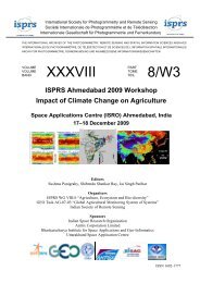
Internati<strong>on</strong>al GEO Workshop <strong>on</strong> <str<strong>on</strong>g>SAR</str<strong>on</strong>g> <str<strong>on</strong>g>to</str<strong>on</strong>g> <str<strong>on</strong>g>Support</str<strong>on</strong>g> <str<strong>on</strong>g>Agricultural</str<strong>on</strong>g> M<strong>on</strong>i<str<strong>on</strong>g>to</str<strong>on</strong>g>ring<br />
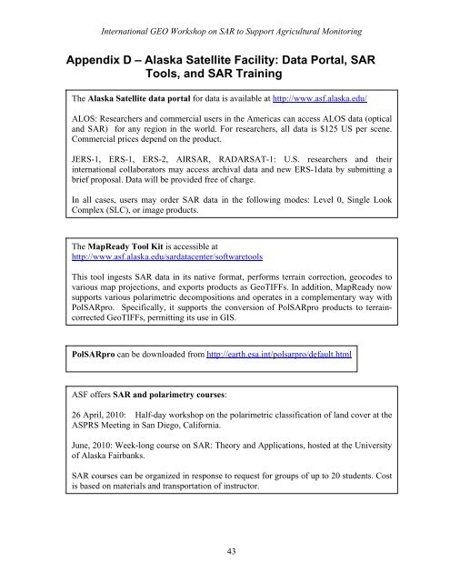
Appendix D – Alaska Satellite Facility: Data Portal, <str<strong>on</strong>g>SAR</str<strong>on</strong>g><br />
Tools, and <str<strong>on</strong>g>SAR</str<strong>on</strong>g> Training<br />
The Alaska Satellite data portal for data is available at http://www.asf.alaska.edu/<br />
ALOS: Researchers and commercial users in the Americas can access ALOS data (optical<br />
and <str<strong>on</strong>g>SAR</str<strong>on</strong>g>) for any regi<strong>on</strong> in the world. For researchers, all data is $125 US per scene.<br />
Commercial prices depend <strong>on</strong> the product.<br />
JERS-1, ERS-1, ERS-2, AIR<str<strong>on</strong>g>SAR</str<strong>on</strong>g>, RADARSAT-1: U.S. researchers and their<br />
internati<strong>on</strong>al collabora<str<strong>on</strong>g>to</str<strong>on</strong>g>rs may access archival data and new ERS-1data by submitting a<br />
brief proposal. Data will be provided free of charge.<br />
In all cases, users may order <str<strong>on</strong>g>SAR</str<strong>on</strong>g> data in the following modes: Level 0, Single Look<br />
Complex (SLC), or image products.<br />
The MapReady Tool Kit is accessible at<br />
http://www.asf.alaska.edu/sardatacenter/software<str<strong>on</strong>g>to</str<strong>on</strong>g>ols<br />
This <str<strong>on</strong>g>to</str<strong>on</strong>g>ol ingests <str<strong>on</strong>g>SAR</str<strong>on</strong>g> data in its native format, performs terrain correcti<strong>on</strong>, geocodes <str<strong>on</strong>g>to</str<strong>on</strong>g><br />
various map projecti<strong>on</strong>s, and exports products as GeoTIFFs. In additi<strong>on</strong>, MapReady now<br />
supports various polarimetric decompositi<strong>on</strong>s and operates in a complementary way with<br />
Pol<str<strong>on</strong>g>SAR</str<strong>on</strong>g>pro. Specifically, it supports the c<strong>on</strong>versi<strong>on</strong> of Pol<str<strong>on</strong>g>SAR</str<strong>on</strong>g>pro products <str<strong>on</strong>g>to</str<strong>on</strong>g> terraincorrected<br />
GeoTIFFs, permitting its use in GIS.<br />
Pol<str<strong>on</strong>g>SAR</str<strong>on</strong>g>pro can be downloaded from http://earth.esa.int/polsarpro/default.html<br />
ASF offers <str<strong>on</strong>g>SAR</str<strong>on</strong>g> and polarimetry courses:<br />
26 April, 2010: Half-day workshop <strong>on</strong> the polarimetric classificati<strong>on</strong> of land cover at the<br />
ASPRS Meeting in San Diego, California.<br />
June, 2010: Week-l<strong>on</strong>g course <strong>on</strong> <str<strong>on</strong>g>SAR</str<strong>on</strong>g>: Theory and Applicati<strong>on</strong>s, hosted at the University<br />
of Alaska Fairbanks.<br />
<str<strong>on</strong>g>SAR</str<strong>on</strong>g> courses can be organized in resp<strong>on</strong>se <str<strong>on</strong>g>to</str<strong>on</strong>g> request for groups of up <str<strong>on</strong>g>to</str<strong>on</strong>g> 20 students. Cost<br />
is based <strong>on</strong> materials and transportati<strong>on</strong> of instruc<str<strong>on</strong>g>to</str<strong>on</strong>g>r.<br />
43