City of Lawrenceville Comprehensive Plan Steering Committee
City of Lawrenceville Comprehensive Plan Steering Committee
City of Lawrenceville Comprehensive Plan Steering Committee

You also want an ePaper? Increase the reach of your titles
YUMPU automatically turns print PDFs into web optimized ePapers that Google loves.
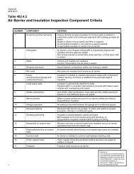
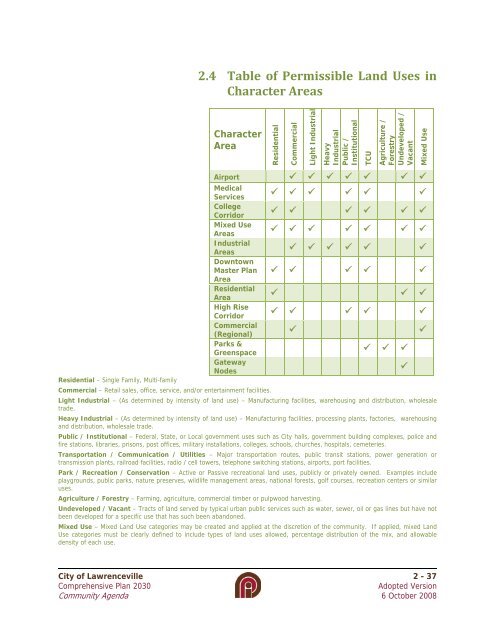
2.4 Table <strong>of</strong> Permissible Land Uses inCharacter AreasCharacterAreaResidentialCommercialLight IndustrialHeavyIndustrialPublic /InstitutionalTCUAgriculture /ForestryUndeveloped /VacantMixed UseAirport Medical ServicesCollegeCorridorMixed UseAreasIndustrialAreasDowntownMaster <strong>Plan</strong>Area Residential AreaHigh Rise CorridorCommercial(Regional)Parks & GreenspaceGatewayNodesResidential – Single Family, Multi-familyCommercial – Retail sales, <strong>of</strong>fice, service, and/or entertainment facilities.Light Industrial – (As determined by intensity <strong>of</strong> land use) – Manufacturing facilities, warehousing and distribution, wholesaletrade.Heavy Industrial – (As determined by intensity <strong>of</strong> land use) – Manufacturing facilities, processing plants, factories, warehousingand distribution, wholesale trade.Public / Institutional – Federal, State, or Local government uses such as <strong>City</strong> halls, government building complexes, police andfire stations, libraries, prisons, post <strong>of</strong>fices, military installations, colleges, schools, churches, hospitals, cemeteries.Transportation / Communication / Utilities – Major transportation routes, public transit stations, power generation ortransmission plants, railroad facilities, radio / cell towers, telephone switching stations, airports, port facilities.Park / Recreation / Conservation – Active or Passive recreational land uses, publicly or privately owned. Examples includeplaygrounds, public parks, nature preserves, wildlife management areas, national forests, golf courses, recreation centers or similaruses.Agriculture / Forestry – Farming, agriculture, commercial timber or pulpwood harvesting.Undeveloped / Vacant – Tracts <strong>of</strong> land served by typical urban public services such as water, sewer, oil or gas lines but have notbeen developed for a specific use that has such been abandoned.Mixed Use – Mixed Land Use categories may be created and applied at the discretion <strong>of</strong> the community. If applied, mixed LandUse categories must be clearly defined to include types <strong>of</strong> land uses allowed, percentage distribution <strong>of</strong> the mix, and allowabledensity <strong>of</strong> each use.<strong>City</strong> <strong>of</strong> <strong>Lawrenceville</strong> 2 - 37<strong>Comprehensive</strong> <strong>Plan</strong> 2030Adopted VersionCommunity Agenda 6 October 2008