- Page 1 and 2: CITY OF MORENO VALLEYGENERAL PLANJU
- Page 3 and 4: PreambleThe City of Moreno Valley e
- Page 5 and 6: TABLE OF CONTENTSMORENO VALLEY GENE
- Page 7: TABLE OF CONTENTSMORENO VALLEY GENE
- Page 11 and 12: TABLE OF CONTENTSMORENO VALLEY GENE
- Page 13 and 14: TABLE OF CONTENTSMORENO VALLEY GENE
- Page 15 and 16: TABLE OF CONTENTSMORENO VALLEY GENE
- Page 17 and 18: CHAPTER 1 - INTRODUCTIONMORENO VALL
- Page 19 and 20: San Bernardino CountyCALIMESA|ÿ 91
- Page 22 and 23: CHAPTER 2 - COMMUNITY DEVELOPMENTMO
- Page 26 and 27: CHAPTER 2 - COMMUNITY DEVELOPMENTTh
- Page 28 and 29: CHAPTER 2 - COMMUNITY DEVELOPMENTEM
- Page 30 and 31: PERRIS BLVDCOLTON UNIFIEDSCHOOL DIS
- Page 32 and 33: CHAPTER 2 - COMMUNITY DEVELOPMENTse
- Page 34: CHAPTER 2 - COMMUNITY DEVELOPMENTAp
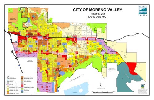
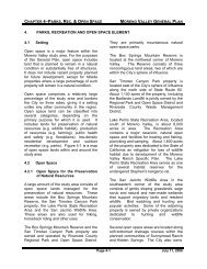
- Page 37 and 38: CHAPTER 4-P ARKS , R EC . & OPEN SP
- Page 39 and 40: CHAPTER 4-P ARKS , R EC . & OPEN SP
- Page 41 and 42: CHAPTER 4-P ARKS , R EC . & OPEN SP
- Page 43 and 44: CHAPTER 4-P ARKS , R EC . & OPEN SP
- Page 45 and 46: CHAPTER 4-P ARKS , R EC . & OPEN SP
- Page 47 and 48: CHAPTER 4-P ARKS , R EC . & OPEN SP
- Page 49 and 50: PERRIS BLVDBoxSpringsMountainRegion
- Page 51 and 52: CHAPTER 5 - CIRCULATIONMORENO VALLE
- Page 53 and 54: CHAPTER 5 - CIRCULATIONMORENO VALLE
- Page 55 and 56: CHAPTER 5 - CIRCULATIONMORENO VALLE
- Page 57 and 58: CHAPTER 5 - CIRCULATIONMORENO VALLE
- Page 59 and 60: CHAPTER 6 - SAFETYMORENO VALLEY GEN
- Page 61 and 62: CHAPTER 6 - SAFETYMORENO VALLEY GEN
- Page 63 and 64: CHAPTER 6 - SAFETYthe entire police
- Page 65 and 66: CHAPTER 6 - SAFETYfour firefighters
- Page 67 and 68: CHAPTER 6 - SAFETYStation No. 91 is
- Page 69 and 70: CHAPTER 6 - SAFETYmeasures must be
- Page 71 and 72: CHAPTER 6 - SAFETYalso promoted by
- Page 73 and 74: Blvd.MorenoQuincy St.Sinclair St.65
- Page 75 and 76:
CHAPTER 6 - SAFETYThe Badlands rang
- Page 77 and 78:
CHAPTER 6 - SAFETYThe Richter Scale
- Page 79 and 80:
CHAPTER 6 - SAFETYUpon completion o
- Page 81 and 82:
CHAPTER 6 - SAFETYStandards - River
- Page 83 and 84:
CHAPTER 6 - SAFETYSunnymead Storm C
- Page 85 and 86:
CHAPTER 6 - SAFETYto allow for cons
- Page 87 and 88:
CHAPTER 6 - SAFETYAPZ II extends an
- Page 89 and 90:
CHAPTER 7 - CONSERVATIONMORENO VALL
- Page 91 and 92:
CHAPTER 7 - CONSERVATIONwas listed
- Page 93 and 94:
CHAPTER 7 - CONSERVATIONIn 1987, th
- Page 95 and 96:
CHAPTER 7 - CONSERVATIONdevelopment
- Page 97 and 98:
PERRIS BLVDNO WATERPURVEYORS AN TI
- Page 99 and 100:
CHAPTER 7 - CONSERVATIONalso reduce
- Page 101 and 102:
PERRIS BLVDCANYON RDS AN TI MOTEORE
- Page 103 and 104:
CHAPTER 8 - HOUSINGMORENO VALLEY GE
- Page 105 and 106:
CHAPTER 8 - HOUSINGMORENO VALLEY GE
- Page 107 and 108:
CHAPTER 8 - HOUSINGMORENO VALLEY GE
- Page 109 and 110:
CHAPTER 8 - HOUSINGSingle parent fa
- Page 111 and 112:
CHAPTER 8 - HOUSINGMORENO VALLEY GE
- Page 113 and 114:
CHAPTER 8 - HOUSINGMORENO VALLEY GE
- Page 115 and 116:
CHAPTER 8 - HOUSINGMORENO VALLEY GE
- Page 117 and 118:
CHAPTER 8 - HOUSINGMORENO VALLEY GE
- Page 119 and 120:
CHAPTER 8 - HOUSINGMORENO VALLEY GE
- Page 121 and 122:
CHAPTER 8 - HOUSING8.3.5 Housing St
- Page 123 and 124:
CHAPTER 8 - HOUSING8.3.7 Elderly He
- Page 125 and 126:
CHAPTER 8 - HOUSINGpersons. The chi
- Page 127 and 128:
CHAPTER 8 - HOUSINGMORENO VALLEY GE
- Page 129 and 130:
CHAPTER 8 - HOUSINGHomeless provide
- Page 131 and 132:
CHAPTER 8 - HOUSINGMORENO VALLEY GE
- Page 133 and 134:
CHAPTER 8 - HOUSINGThe Regional Hou
- Page 135 and 136:
CHAPTER 8 - HOUSINGMORENO VALLEY GE
- Page 137 and 138:
CHAPTER 8 - HOUSINGMORENO VALLEY GE
- Page 139 and 140:
CHAPTER 8 - HOUSINGThe only residen
- Page 141 and 142:
CHAPTER 8 - HOUSINGMORENO VALLEY GE
- Page 143 and 144:
CHAPTER 8 - HOUSINGMORENO VALLEY GE
- Page 145 and 146:
CHAPTER8 - HOUSINGMORENO VALLEY GEN
- Page 147 and 148:
CHAPTER 8 - HOUSINGMORENO VALLEY GE
- Page 149 and 150:
CHAPTER 8 - HOUSINGlocated within t
- Page 151 and 152:
CHAPTER 8 - HOUSINGMORENO VALLEY GE
- Page 153 and 154:
CHAPTER 8 - HOUSING8.6.3 Mobilehome
- Page 155 and 156:
CHAPTER 8 - HOUSINGconstruction of
- Page 157 and 158:
CHAPTER 8 - HOUSING8.6.7 Permit Pro
- Page 159 and 160:
CHAPTER 8 - HOUSING7. Drive aisles
- Page 161 and 162:
CHAPTER 8 - HOUSINGMORENO VALLEY GE
- Page 163 and 164:
CHAPTER 8 - HOUSINGMORENO VALLEY GE
- Page 165 and 166:
CHAPTER 8 - HOUSING8.6.12 Developme
- Page 167 and 168:
CHAPTER 8 - HOUSINGproperties or im
- Page 169 and 170:
CHAPTER 8 - HOUSINGMORENO VALLEY GE
- Page 171 and 172:
CHAPTER 8 - HOUSING8.7 OVERVIEW: HO
- Page 173 and 174:
CHAPTER 8 - HOUSINGMORENO VALLEY GE
- Page 175 and 176:
CHAPTER 8 - HOUSINGMORENO VALLEY GE
- Page 177 and 178:
CHAPTER 8 - HOUSINGMORENO VALLEY GE
- Page 179 and 180:
CHAPTER 8 - HOUSINGMORENO VALLEY GE
- Page 181 and 182:
CHAPTER 8 - HOUSINGHOUSING ELEMENT
- Page 183 and 184:
CHAPTER 8 - HOUSINGMORENO VALLEY GE
- Page 185 and 186:
CHAPTER 8 - HOUSINGMORENO VALLEY GE
- Page 187 and 188:
CHAPTER 8 - HOUSINGMORENO VALLEY GE
- Page 189 and 190:
CHAPTER 8 - HOUSINGMORENO VALLEY GE
- Page 191 and 192:
CHAPTER 8 - HOUSINGMORENO VALLEY GE
- Page 193 and 194:
CHAPTER 8 - HOUSINGMORENO VALLEY GE
- Page 195 and 196:
CHAPTER 8 - HOUSINGMORENO VALLEY GE
- Page 197 and 198:
CHAPTER 8 - HOUSINGMORENO VALLEY GE
- Page 199 and 200:
CHAPTER 8 - HOUSINGMORENO VALLEY GE
- Page 201 and 202:
CHAPTER 8 - HOUSINGMORENO VALLEY GE
- Page 203 and 204:
CHAPTER 8 - HOUSINGMORENO VALLEY GE
- Page 205 and 206:
CHAPTER 8 - HOUSINGMORENO VALLEY GE
- Page 207 and 208:
CHAPTER 8 - HOUSINGMORENO VALLEY GE
- Page 209 and 210:
CHAPTER 8 - HOUSINGMORENO VALLEY GE
- Page 211 and 212:
CHAPTER 8 - HOUSINGMORENO VALLEY GE
- Page 213 and 214:
CHAPTER 8 - HOUSINGMORENO VALLEY GE
- Page 215 and 216:
CHAPTER 8 - HOUSINGMORENO VALLEY GE
- Page 217 and 218:
CHAPTER 8 - HOUSINGMORENO VALLEY GE
- Page 219 and 220:
CHAPTER 9 - GOALS AND OBJECTIVESMOR
- Page 221 and 222:
CHAPTER 9 - GOALS AND OBJECTIVESb.
- Page 223 and 224:
CHAPTER 9 - GOALS AND OBJECTIVESMOR
- Page 225 and 226:
CHAPTER 9 - GOALS AND OBJECTIVESObj
- Page 227 and 228:
CHAPTER 9 - GOALS AND OBJECTIVESObj
- Page 229 and 230:
CHAPTER 9 - GOALS AND OBJECTIVESMOR
- Page 231 and 232:
CHAPTER 9 - GOALS AND OBJECTIVESMOR
- Page 233 and 234:
CHAPTER 9 - GOALS AND OBJECTIVEScri
- Page 235 and 236:
CHAPTER 9 - GOALS AND OBJECTIVES9.4
- Page 237 and 238:
CHAPTER 9 - GOALS AND OBJECTIVESseg
- Page 239 and 240:
CHAPTER 9 - GOALS AND OBJECTIVESMOR
- Page 241 and 242:
CHAPTER 9 - GOALS AND OBJECTIVESsid
- Page 243 and 244:
CHAPTER 9 - GOALS AND OBJECTIVESMOR
- Page 245 and 246:
LOS D is applicable to intersection
- Page 247 and 248:
PERRIS BLVDCANYON RDS AN TI MOTEORE
- Page 249 and 250:
CHAPTER 9 - GOALS AND OBJECTIVESObj
- Page 251 and 252:
CHAPTER 9 - GOALS AND OBJECTIVES6.9
- Page 253 and 254:
CHAPTER 9 - GOALS AND OBJECTIVESMOR
- Page 255 and 256:
CHAPTER 9 - GOALS AND OBJECTIVES7.4
- Page 257 and 258:
CHAPTER 9 - GOALS AND OBJECTIVESMOR
- Page 259 and 260:
CHAPTER 9 - GOALS AND OBJECTIVESup
- Page 261:
CHAPTER 10 - GLOSSARYthe pipelines,