Climate Action 2011-2012

Create successful ePaper yourself
Turn your PDF publications into a flip-book with our unique Google optimized e-Paper software.
Special feature<br />
research in Motion<br />
<strong>Climate</strong> change adaptation –<br />
disaster response and Blackberry<br />
104 climateactionprogramme.org<br />
The US NaTioNal WeaTher Service<br />
The US National Weather Service (NWS) is a federal<br />
government agency of the National Oceanic and<br />
Atmospheric Administration. NWS meteorologists perform<br />
post-storm damage surveying, where they collect key data on<br />
storm events and ultimately update a national database for<br />
scientific, academic, commercial and public use.<br />
The challeNge<br />
Surveying damage from severe storms is an important mission<br />
of the US National Weather Service (NWS). This labourintensive<br />
work requires field surveyors to travel to storm sites<br />
and document the damage left behind by major weather<br />
events such as tornadoes. Areas to be surveyed can span<br />
lengths of 15 miles or longer. Surveyors would document data<br />
gathered at the storm sites using pen and paper.<br />
Keith Stellman, Warning Coordination Meteorologist<br />
with NWS, says one major challenge of this field operation<br />
is maximising the accuracy of the collected data. “Surveying<br />
a tornado track can involve pages of handwritten notes,<br />
GPS co-ordinates, and calculations. Once notes are made,<br />
surveyors must travel back to the office to enter all of that<br />
data manually,” Stellman explains. In the process of entering<br />
the information, detailed notes made at the scene are often<br />
summarised, and any details that weren’t written down<br />
immediately can be forgotten.<br />
The SolUTioN<br />
NWS implemented Freance Mobile software, developed<br />
by TDC Group Inc., to accelerate the data collection and<br />
data entry process on BlackBerry® smartphones in the hands<br />
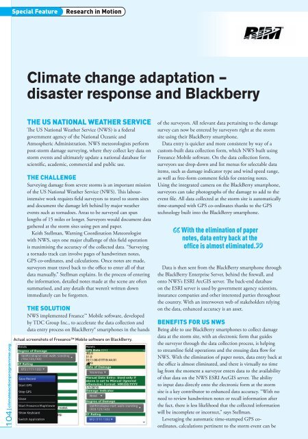
Actual screenshots of Freeance Mobile software on BlackBerry.<br />
of the surveyors. All relevant data pertaining to the damage<br />
survey can now be entered by surveyors right at the storm<br />
site using their BlackBerry smartphone.<br />
Data entry is quicker and more consistent by way of a<br />
custom-built data collection form, which NWS built using<br />
Freeance Mobile software. On the data collection form,<br />
surveyors use drop-down and list menus for selectable data<br />
items, such as damage indicator type and wind speed range,<br />
as well as free-form comment fields for entering notes.<br />
Using the integrated camera on the BlackBerry smartphone,<br />
surveyors can take photographs of the damage to add to the<br />
event file. All data collected at the storm site is automatically<br />
time-stamped with GPS co-ordinates thanks to the GPS<br />
technology built into the BlackBerry smartphone.<br />
With the elimination of paper<br />
notes, data entry back at the<br />
office is almost eliminated.<br />
Data is then sent from the BlackBerry smartphone through<br />
the BlackBerry Enterprise Server, behind the firewall, and<br />
onto NWS’s ESRI ArcGIS server. The back-end database<br />
on the ESRI server is used by government agency scientists,<br />
insurance companies and other interested parties throughout<br />
the country. With an interwoven web of stakeholders relying<br />
on the data, enhanced accuracy is an asset.<br />
BeNefiTS for US NWS<br />
Being able to use BlackBerry smartphones to collect damage<br />
data at the storm site, with an electronic form that guides<br />
the surveyor through the data collection process, is helping<br />
to streamline field operations and the ensuing data flow for<br />
NWS. With the elimination of paper notes, data entry back at<br />
the office is almost eliminated, and there is virtually no time<br />
lag from the moment a surveyor enters data to the availability<br />
of that data on the NWS ESRI ArcGIS server. The ability<br />
to input data directly onto the electronic form at the storm<br />
site is a key contributor to enhanced data accuracy. “With no<br />
need to review handwritten notes or recall information after<br />
the fact, there is less likelihood that the collected information<br />
will be incomplete or incorrect,” says Stellman.<br />
Leveraging the automatic time-stamped GPS coordinates,<br />
calculations pertinent to the storm event can be